Les Prairies du Canal eco-district
Last modified by the author on 27/02/2023 - 19:54

- Address 1 - street : Rue Le Corbusier 67400 ILLKIRCH-GRAFFENSTADEN, France
- Population : 3 000 hab
- Number of jobs : 80 emplois
- Starting year of the project : 2011
- Delivery year of the project : 2029
Certifications :

-
14 ha -
29 000 000 €
This project won a mention at the French and international levels for the New District Grand Prize of the Green Solutions Awards 2022-2023.
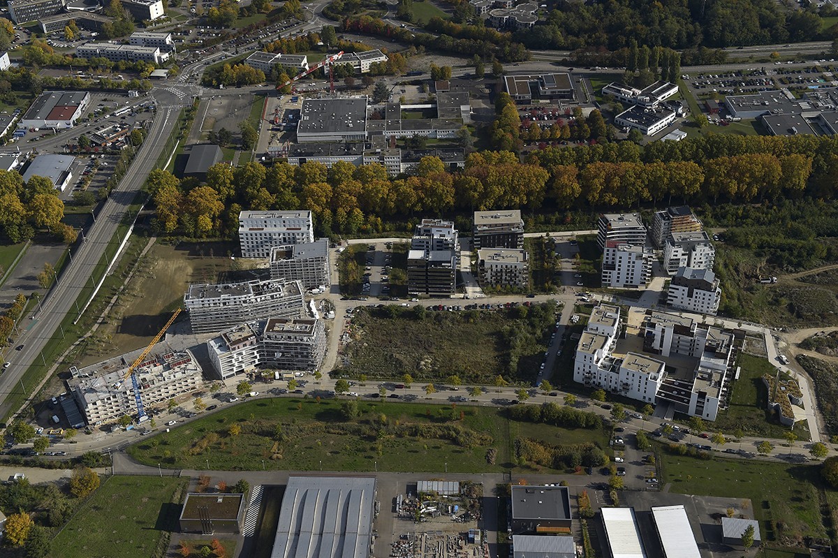
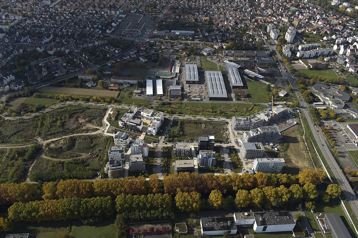
Between the Rhône-Rhine canal and rue Le Corbusier, the “Les Prairies du Canal” eco-district occupies a strategic position halfway between the Innovation Park and the city center of Illkirch-Graffenstaden, the third largest city of the Eurometropolis of Strasbourg.
The development program designed by SERS aims to provide environmental consistency with the presence of nature in the architecture. The height is favored to free up more than 80% of the footprint. This site of 14 ha and 1,250 housing units in the long term offers landscape qualities, the main ones being undoubtedly the presence of the canal and the development of natural spaces.
The project is designed around a landscape network that allows both the integration of constructions in a high quality natural environment, to manage all rainwater and to offer biodiversity a support to flourish.
The project was designed to reduce the impacts in terms of development and construction. SERS encourages developers to go beyond regulations alone to design buildings that emit less GHGs and consume less energy. As such, the share of wood in the constructions of the second phase is significant and a heating network has been implemented on the scale of the district, the thermal performance of the buildings also exceeds the regulations to limit consumption.
Programme
- Housing
- Businesses and services
- Public spaces
- Green spaces
CO2 Impact
1 900 tCO2
Method used to calculate CO2 impact
Simulation effectuée sur le logiciel Urban Print, qui permet de comparer le quartier en question avec un quartier de référence qui suit le règlement en vigueur.
Project progress
- Delivery phase
- Operational phase
Procedure type
- Urban développement permit
Key points
- Quality of life
- Resources
- Biodiversity
- Energy /Climate
Approaches used
- Ecodistrict national label
Certifications
- Ecodistrict national label
Data reliability
3rd part certified
Photo credit
Quentin Duret
Laurent Rothan - Airmegapix
Type of territory
The Eurometropolis of Strasbourg (EMS) transferred the plot which today hosts the project to the SERS, local SEM, to ensure global urban development consistent with the strategic orientations:
- of the land-use plan (POS) then of the local ubran development plan (PLU)
- the Housing Zones Orientation Plan which identified the site as a high-potential urbanization zone
- of the Local Housing Program which confirmed the general objectives of the municipality
With regard to these elements, the City and the EMS have studied the methods of a coherent urbanization of this sector initially called "Le Corbusier".
The "Le Corbusier" sector thus provided an opportunity to convert agricultural land and build a new homogeneous district of high architectural and urban quality. The development program provided for the construction of approximately 1,200 housing units on a 14 ha site, for a total floor area of approximately 102,000 m2. The land initially dedicated to monoculture was accompanied by a wooded area along the canal. This afforestation was very degraded by the presence of Robinia, which is an invasive species.
The progressive urbanization of the sector must be done in continuity with the existing one, while creating for this district a strong, innovative identity, which explores new ways of living and making the city and responding to the principles of sustainable development.
The programming took into account several issues, in particular the existing socio-economic environment. The immediate proximity of the university campus which has 2,500 students and 1,500 teacher-researchers, supplemented by the 4,500 employees of the innovation park which brings together a hundred companies of international scope in the field of Research & Development, offers a potentially looking for accommodation close to their place of work. This attractiveness was reinforced by the extension of the tram line in May 2016, which allows direct access to the city center of Illkirch-Graffenstaden and to all the structural facilities.
It is also a question of developing a few commercial cells to meet the expectations of future residents in terms of services and shops in order to limit travel and favor proximity.
Intergenerationality is also at the heart of the project with the construction of a senior residence with a social vocation which meets the demand of elderly people who are not dependent on the municipality.
Finally, a diagnosis of the existing networks highlighted their presence nearby to allow easy connection of the new district to the dealer networks.
In terms of possible developments, we can cite the example of the heating network which was implemented at the district level. It has been sized to allow it to be powered by several energy sources. It is currently supplied by a biomethane boiler room (minimum coverage of 60%) but is compatible with the deep geothermal system currently under study in the municipality of Illkirch.
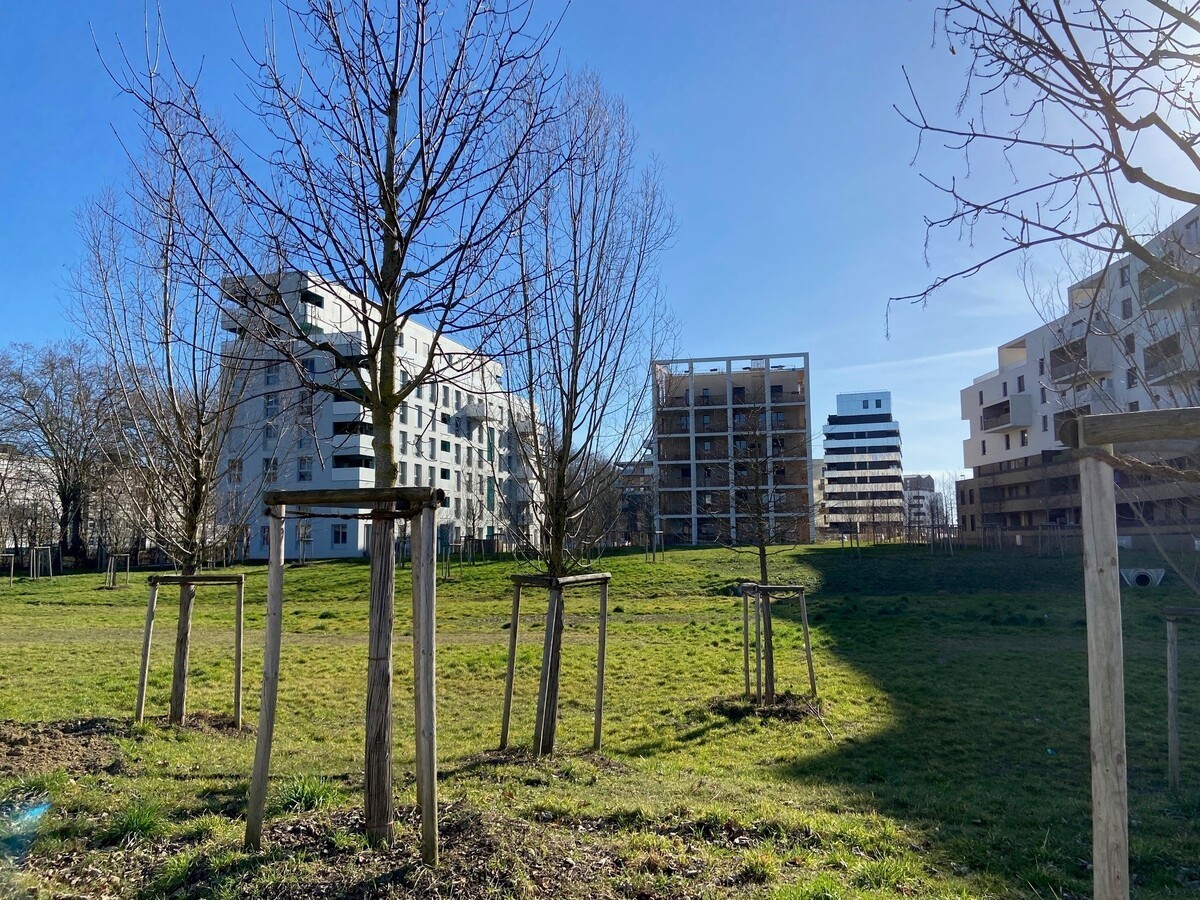
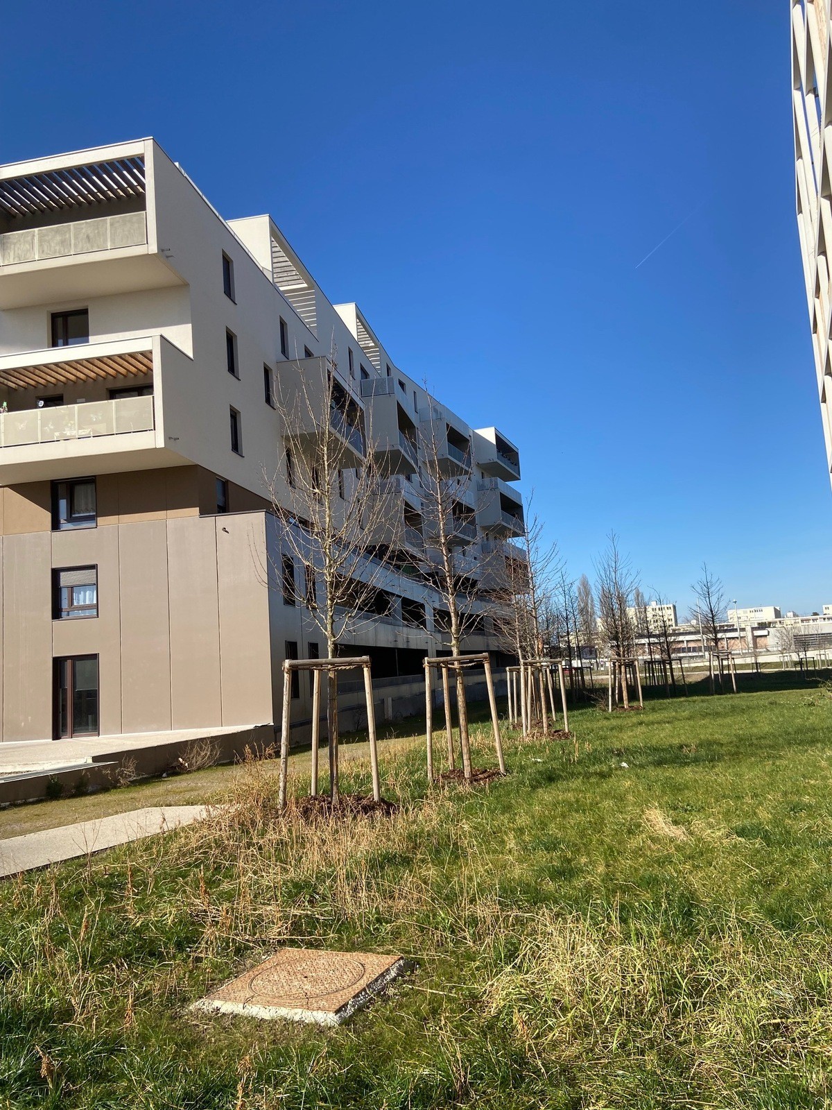
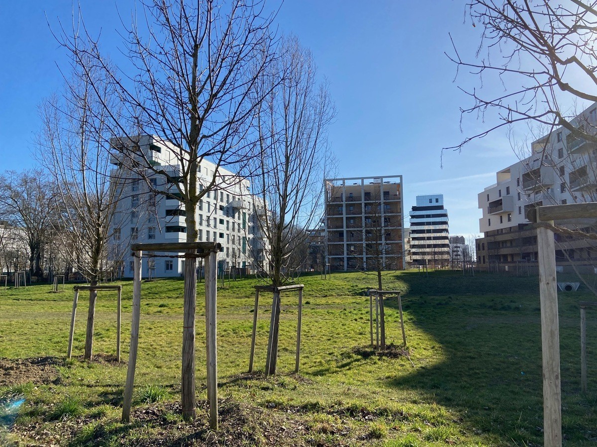
The significant presence of vegetation and in particular trees with tall stems (plantation of more than 1000 trees) also makes it possible to deal with global warming by providing shade in summer and allowing light to penetrate buildings in winter.
Climate zone
[Cfb] Marine Mild Winter, warm summer, no dry season.
Land price
500 €/m²
More info
https://sers.eu/realisations/prairies-canal-illkirch/Neighbourhood paved surfaces
68 000 m²
Built surface on natural or agricultural spaces
14,00 ha
Green areas, roofs included
77 000 m²
Public spaces area
64 500 m²
Commercial floor area
2 000 m²
Housing floor area
94 000 m²
Number of residential units
1 250
Number of social housing units
481
Project holder
Project management
- the SERS project manager,
- the Operational Director of SERS
- the Director General of SERS,
- the Director of Planning, Urban Planning and Sustainable Development of the City of Illkirch,
- all the technical services of the Eurometropolis of Strasbourg (EMS) and the City of Illkirch.
- Agence TER in Paris - Landscaper Urbanist representative of the team
- Lollier Ingénierie in Mittelschaeffolsheim - thermal consultancy agency VRD and landscaping
- The Atelier d'Ecologie Urbaine in Dampierre-sur-Linotte - thermal consultancy agency Environment and Urban Ecology
- Item in Besançon - Transport and travel engineering
- Solares Bauen in Strasbourg - Thermal engineering and renewable energies.
- External works project management (OA + Management of the works contract missions): Berest in Illkirch - external works consultancy agency and Acte 2 Paysage in Obernai - Landscaper
- Project management assistance for the implementation of a heating network: Energival in Strasbourg
- From the Mayor of Illkirch
- From the town planning assistant
- From the Environmental Assistant
- From the Director General of Services
- From the Director of Planning, Urban Planning and Sustainable Development
- From the Director General of SERS
- From the SERS project manager
Project stakeholders
TER agency
Urbanism agency
Urban planner Landscape designer developed the project up to the Preliminary studies phase and the formalization of the development permit. Also ensures a VISA mission on building permits and on the PRO of public spaces.
contact[a]agenceter.com
https://agenceter.com/project/ecoquartier-le-corbusier
Solar building
Environmental consultancy agency
Sustainable Development Project Assistant, shares the VISA on PCs with the TER agency and advises SERS on the trade-offs to be made concerning environmental issues.
sadoul[a]solares-bauen.fr
https://www.solares-bauen.fr/presentation/
Berest
Construction manager
Has an urban construction management mission, formalizes the project and continues the site until the reception of the works for public spaces.
roger.nuber[a]berest.fr
https://www.berest.fr/qui-sommes-nous/
Act2 landscape
Construction manager
Landscape architect in consortium with BEREST for the urban construction management mission on the implementation of plantations and street furniture.
emmanuelkateb[a]acte2paysage.fr
http://www.acte2paysage.fr/
Canal Meadows Association
Other
Association which represents the inhabitants of the district and more particularly of the first tranche. The association is very involved in the life of the district and is associated by the SERS with the deployment of the rest of the district.
https://lesprairiesducanal.fr/
Quality of life / density
The priority objective of any responsible ecological policy is to limit the consumption of natural or agricultural space by fighting against urban sprawl. The challenge set by the City from the start of the project was to densify as much as possible, in particular to meet the objectives set by the Local Housing Plan of 2009, among other terms for the production of social housing. Thus, the floor area generated by the project corresponds to the maximum authorized by the urban land-use plan then in force (102,000 m²). The local urban development plan adopted in January 2017 confirms all of these rules.
This agricultural wasteland wedged between the canal and more recent districts in a dense fabric had every reason to urbanize in the medium term. Thus, the articulation with the context is done by the landscape which structures the whole of the urban project. The footprint of the buildings is largely optimized to create generous green spaces with a variety of uses.
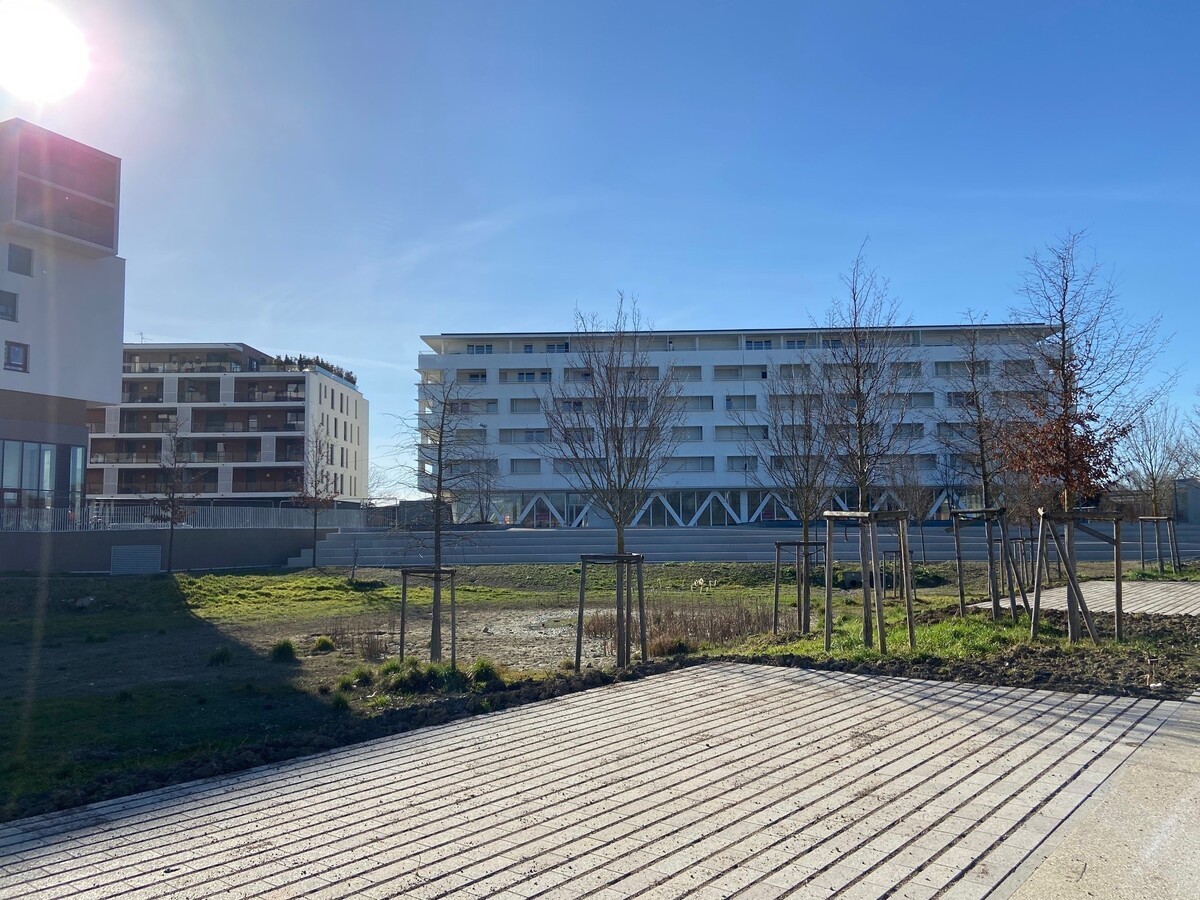
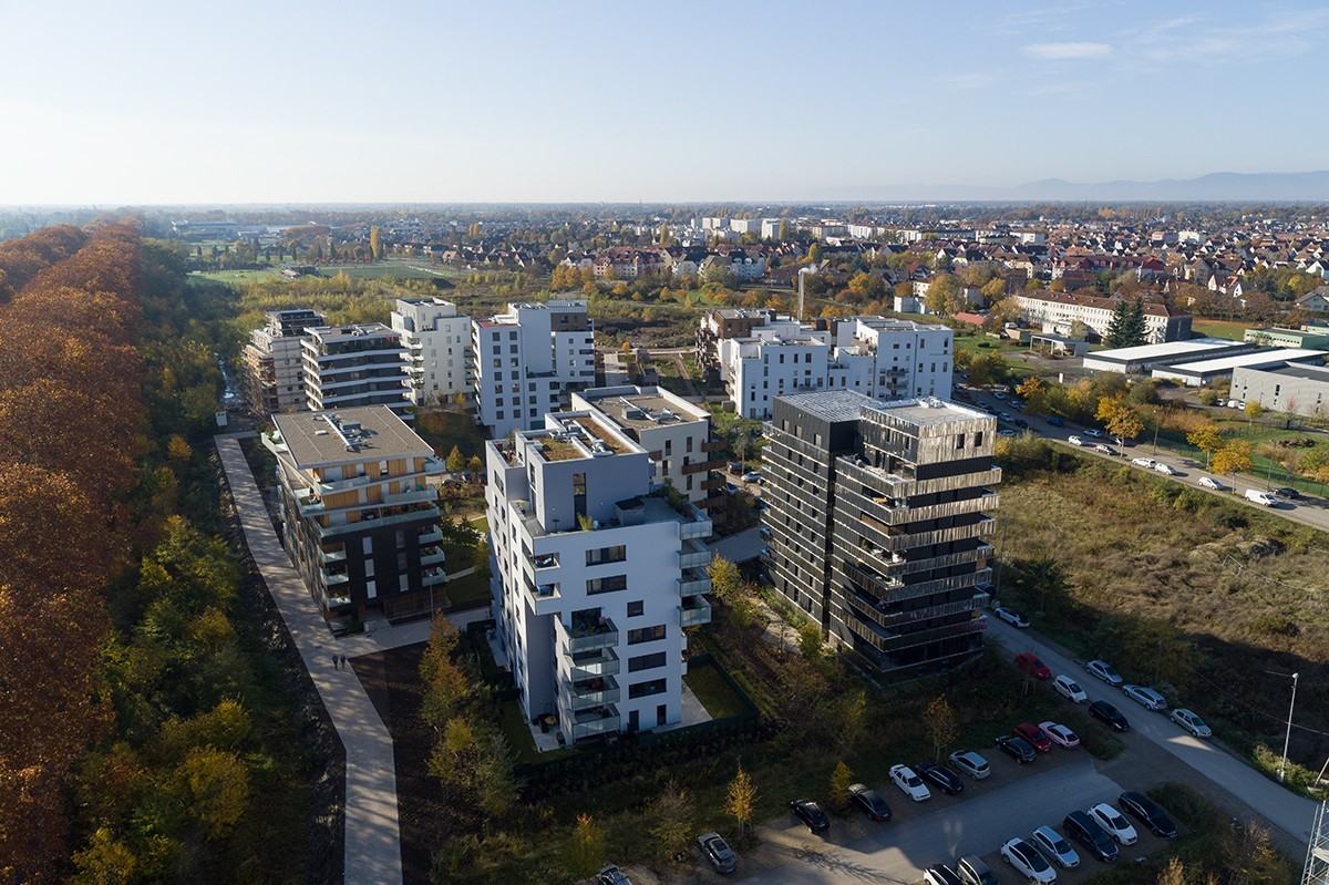
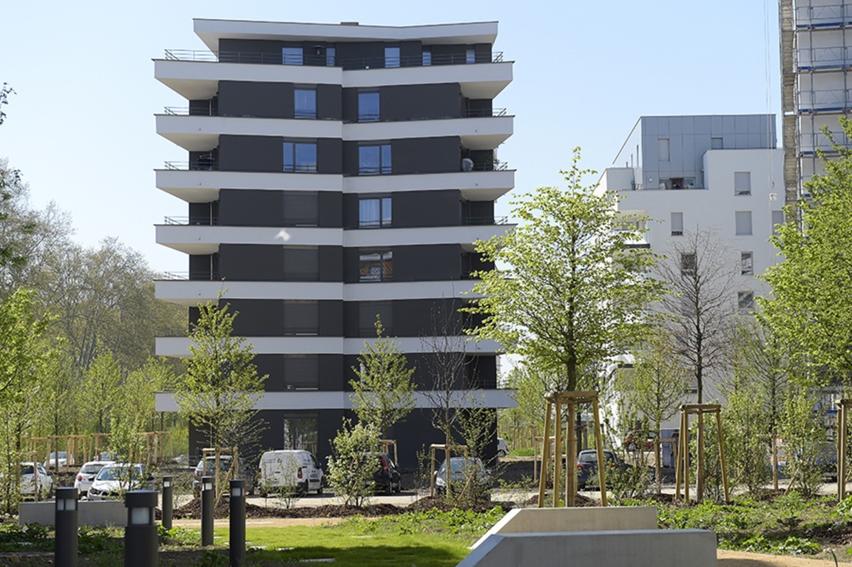
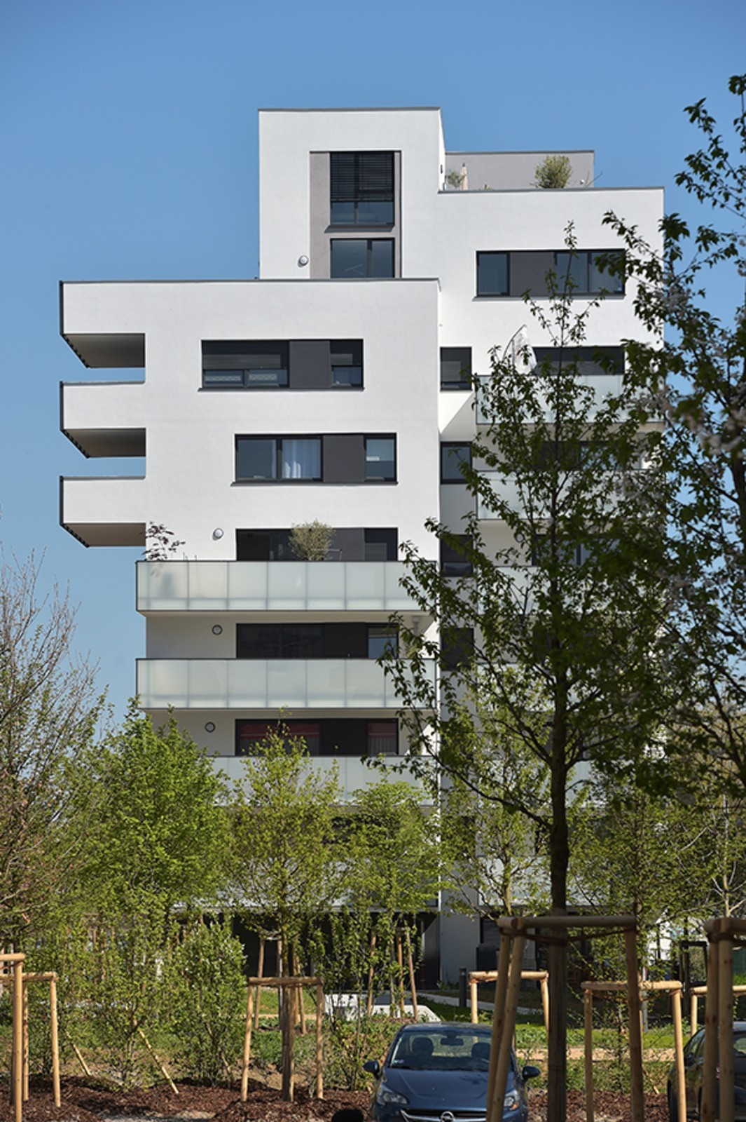
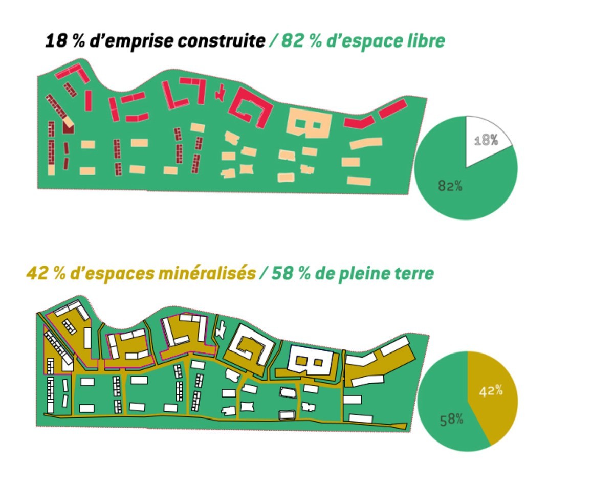
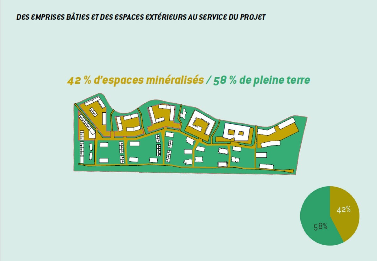
The other stated ambition was the preservation of quality public spaces with a strong presence in terms of proportions. Thus, the urban project, heavily wooded and planted, offers a large place to the landscape by offering 17% of built area and 83% of free space. This will leads to the realization of relatively high real estate programs (going up to G+7 for some).
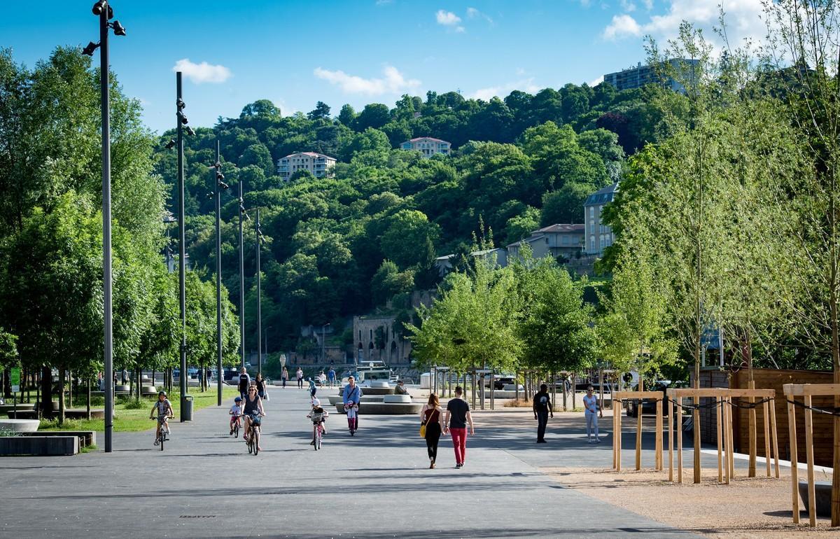
It should also be noted that the site is effectively served by the tram and cycle paths, which led to the proposal to reduce the place of the car on the surface, in favor of soft mobility.
The built typologies combine compactness and dialogue with the landscape thanks to the creation of generous exterior extensions (ground floor gardens, balconies, loggias, terraces, etc.).
Each landscape sequence thus corresponds to a built typology designed in such a way as to offer a qualitative and specific relationship between the interior of the dwellings and the external environment. The project can be broken down into three sectors:
- The blocks of urban orchards are aligned along rue Le Corbusier. These islands are located between the orchards and bordered by the linear vegetable gardens.
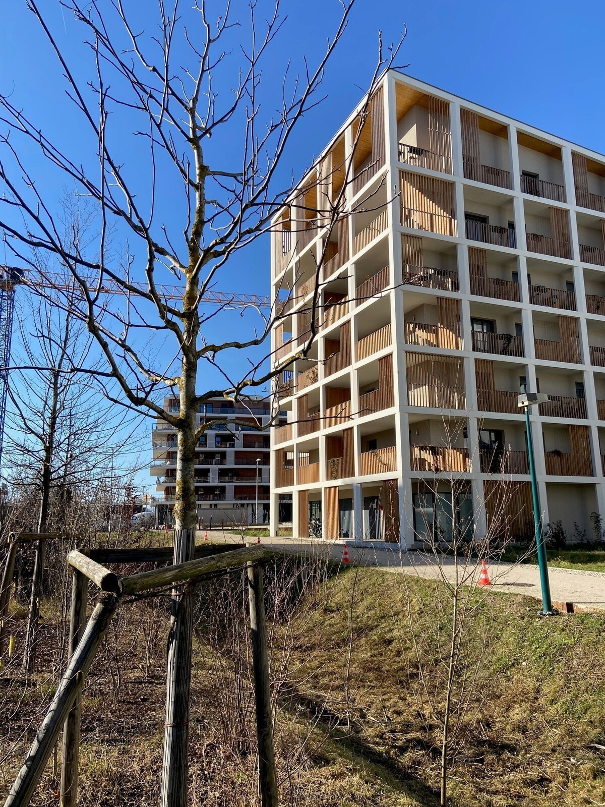
- The islands of light wood are made up of elongated studs scattered throughout the wood. These buildings are designed to the same scale as the large trees in the light wood.
- To the north, in contact with rue Lixenbuhl, a third typology appears: that of the entrance to the district. It is a hybrid morphology between orchard islands and elongated blocks of light wood. Higher than the constructions of the urban orchards, these buildings mark the entrance esplanade of the district and accommodate all the surfaces reserved for commercial activities.
The density distribution is evenly balanced in light wood and in urban orchards.
Culture and heritage
The site being free of any construction before the development of the district, the built heritage was non-existent. In addition, its landlocked position gives it few links with neighboring buildings.
To meet density requirements while preserving generous public spaces on the ground, the town planner decided to "disperse" relatively high real estate programs (up to G+7) in the eastern part of the district, which also allows to provide wide views of the canal from the upper floors of the buildings and thus to enhance it.
During urban studies, the forecourt of the esplanade to the very north of the site has also been redesigned to create a dialogue and thus highlight the newly created forecourt of the neighboring high school (see attached schematic plan).
The fauna/flora study did not highlight any major issues for the natural environment. No protected plant species have been identified. On the other hand, several protected animal species (birds, mammals and reptiles) were observed. These are common species with no particular challenges. Moreover, the area in question was one of the last non-urbanized sectors of the municipality of Illkirch-Graffenstaden, west of the Rhône-Rhine canal. Although "banal", the biodiversity encountered in this sector found refuge in these last semi-natural spaces that constituted the hedges, the woods and the hems. These environments also acted as a corridor that allowed fauna and, to a lesser extent, flora to move around, particularly along the Rhône-Rhine canal.
It should also be noted that a wetland was present in the northern part of the site, which very naturally led to the establishment of the large wet meadow, an area for collecting the neighborhood's rainwater, at this location.
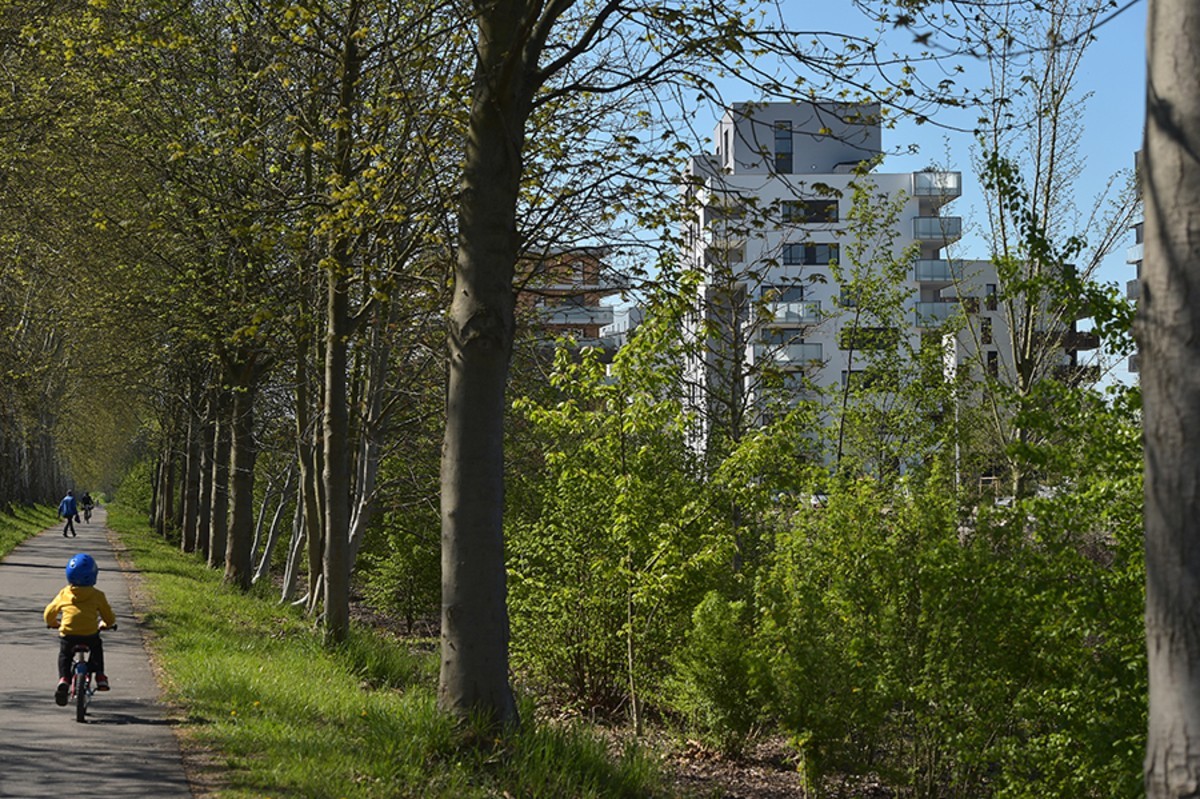
In terms of enhancing the natural heritage, it is also worth mentioning the wood and the existing cycle path along the canal. From the start of the servicing work, the wood was enhanced by having been rid of its invasive species and "expanded" to have several seasons of life to its credit when the first inhabitants arrived. Pedestrian paths meander there and give direct access to the cycle path and the canal which are thus also highlighted. Even if the existing wood was of little ecological interest and was mainly colonized by invasive species, several local residents came forward through the voice of Illkirch's elected officials during the clearing and cleaning of the site, thus several subjects dedicated to be sacrificed, were ultimately preserved.
As the site of the new district was originally dedicated only to monoculture, it presents very little heritage interest. The archaeological excavations carried out were not fruitful.
Mention should also be made here of the work carried out with a historical association in Illkirch, namely the "Fruits et Fleurs" association, which has largely participated in the choice of local species of fruit trees and shrubs which will take place in the orchards and which has benefit planners and landscapers from their feedback.
Social diversity
By offering a wide "range of housing types, the urban program can accommodate a diversity of households (single-parent family, single person, etc.) and lifestyles. For example, housing on the ground floor and attics offer large terraces and/or gardens. Most of them are 3 or 4 rooms (or even more) intended for families.
In order precisely to attract families (the City has undergone an aging of its population in recent years), builders have been asked (with some exceptions) to develop projects for which the average SP of housing does not go below the 65 m².
Regarding lifestyles and more particularly uses related to travel, everyone finds their place thanks to a varied offer:
- The operations of the urban orchards are built on a buried base which accommodates a parking lot with direct access from the accommodation,
- Those in light wood do not benefit from underground parking, which makes it possible to eliminate a large part of car traffic and related nuisances, the places being all grouped together in "urban orchards".
To meet the ambitions of the local housing program (PLH), diversity has been sought and the programming defined as follows:
for tranche 1: 25% of subsidized rental housing, 15% in social accession, 5% in self-promotion and 55% in free accession, for tranche 2: 30% of subsidized rental housing, 10% in social accession, 5% in self-promotion and 55% free admission.
Social housing operations are dispatched to the neighborhood in order to avoid any "ghettoization".
Thanks to the orientation of the buildings and the épannelage imposed by the composition plan, the intimacy of the inhabitants is preserved thanks to a reflection on the distributive modes, the functional organization, the interior / exterior relationship.
Finally, at the level of condominiums and private spaces, the Architectural, Urban, Landscape and Environmental Specifications Manual for Local Housing strongly encouraged the creation of convivial places.
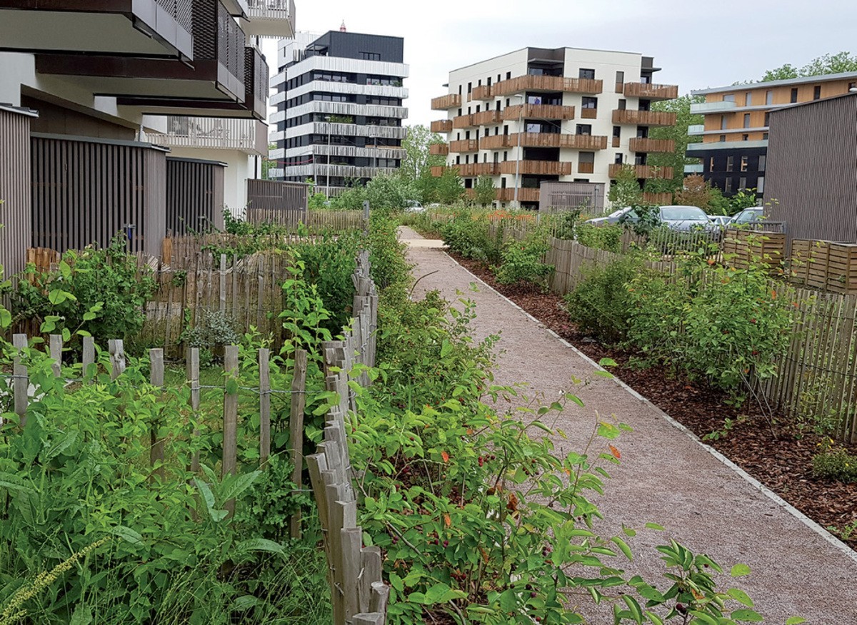
For example, in the urban orchard sector, shared vegetable gardens accompany the main promenade; the courtyards, in the heart of the island, generously sized, are laid out in such a way as to encourage exchanges (benches, green spaces, etc.); the privacy of the semi-private gardens is ensured by plant barriers; shared terraces are also fitted out on the roofs.
In the light wood sector, the outdoor spaces are mainly collective and decorated with many trees. Shared terraces are fitted out and the Perspective program even includes a guest bedroom shared between all the co-owners.
In direct proximity to the lively esplanade and the tram stop, the mixed care home/seniors residence project naturally found its place. It also includes a multipurpose room managed by the City open to the inhabitants of the district (all public and private spaces are of course designed in compliance with accessibility standards).
Social inclusion and safety
In terms of support for the local economy, for several years, SERS has been leading, in close collaboration with the job site relay, a proactive approach for the integration of integration clauses in all the works contracts it signs. Thus, all the companies already selected or which will be selected later for the realization of the servicing and development works undertake to provide a minimum of hours of integration (unemployed people, apprentices,...) as part of the performance of its contract. The hours of insertion represent a criterion for judging offers during allocations. In the same spirit, the SERS requires, through deeds of sale, promoters and lessors to commit to this approach.
Ambient air quality and health
During the construction phase, particular attention was paid to the choice of products used. Thus, the following products were imperatively labeled A+ (within the meaning of the decree of April 19, 2011):
- Construction products and materials, wall and floor coverings, paints and varnishes:
- Floor, wall and ceiling coverings;
- Partitions and false ceilings;
- Insulation products;
- Exterior wood furnishings;
- Products intended for laying and preparing products.
The floor paints, or on wood or metal supports will be labeled NF environment (VOC content < 100g/L). The use of paints containing glycol ethers is prohibited. Adhesives used for flooring will have an EC1+ classification (very low emission) according to the EMICODE system.
Textile floor coverings will benefit from the “European Ecolabel” label or equivalent (GUT type).
Treated wood used in contact with the interior environment must be CTB-B+ certified or the treatment products are CTB-P+ certified (or equivalent).
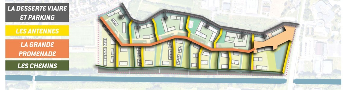
As far as nuisances related to car traffic are concerned (noise, air pollution, smells), the principle of the urban project was to favor soft modes. Thus, the main promenade, the main artery of the district, is treated as a meeting area, which is moreover a one-way street. Apart from the few delivery and PMR spaces scattered along this road, surface parking facilities were prohibited by the town planning regulations then in force. This is entirely relegated to the basement under the buildings of the urban orchards. These shared car parks are directly accessible from rue Le Corbusier. The routes that serve the light wood dwellings are only accessible by so-called service vehicles (waste collection, post office, emergency vehicles, etc.) thanks to the installation of removable bollards. The entire eastern half of the district is therefore completely free of daily car traffic.
SOLUTIONS
- Urban densification
Enhancement of natural spaces to improve the living environment
The urban and landscape project of the prairies of the canal contains various generous public spaces, aiming to minimize artificial spaces to enhance biodiversity.
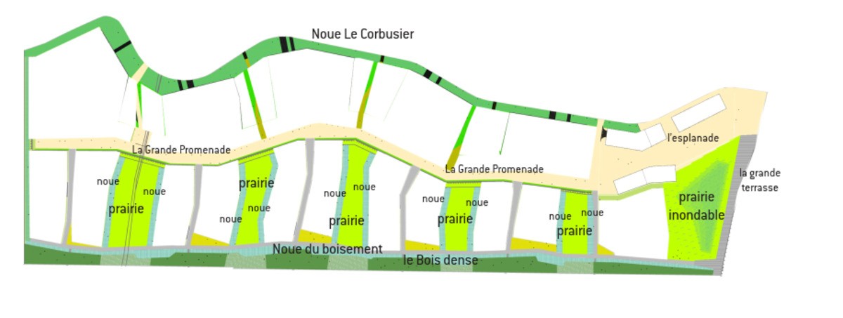
A wide esplanade constitutes the main pedestrian entry sequence into the Prairies du Canal district from Lixenbuhl Street and initiates the mineral landscape of the Grande Promenade. It concentrates all the commercial and service spaces there, and thus constitutes the most urban part of the district. It articulates the natural space of the large wet meadow, the city and the more residential area. It is randomly planted with a few large trees whose species are identical to those of the Grande Promenade.
The terminal water management structure is a layered set of water and wetland ecosystems. It includes a filtering trench, a water basin, a sunken garden, a floodplain. The project proposes a new public space that connects rue Lixenbuhl to the canal by creating a large platform/belvedere below the tramway. Facing south, it will benefit both students from schools and colleges located in the direct vicinity of the site and the inhabitants of the district. The significant setback of the first buildings (65m) highlights the natural and variable landscape of a large wet meadow. This is the first image of the district given to be seen from Lixenbuhl street and the tramway.
The meadows are natural areas with a recreational function open to the sky and to the horizon of the canal. They guarantee the perception of the depth of the site from the majority of the dwellings, and the continuity of the different ecological sequences. They also constitute an important part of the public spaces of the housing estate.
Local development
The Prairies du Canal project is intended as a new center of balance for the territory. Today, the Rhône-Rhine canal serves as a real border between two sections of the city that face each other. This densification must give a new image to the district, more attractive and positive, by offering the possibility for this program to become the link between the city center and the innovation park (100 companies, 4500 employees, 2500 students on the campus). The project contributes to the economic dynamism of the territory by bringing about 3,000 new inhabitants who are all potential customers for the businesses in the area.
Even if commercial cells are programmed at the foot of the building (up to a few hundred m2), particular attention has been given to the complementarity of the offer so as not to compete with the shopping center and the shops in the center. -city which are accessible by tram. In order to be able to respond to any changes in demand, all of the ground floors of the so-called "urban orchard" buildings, which overlook the main promenade, are designed to provide a ceiling height of 3 .50 m to allow their reversibility and the installation of shops or services.
In agreement with the builders selected, it was decided to build the real estate programs of the esplanade, once the first inhabitants have already arrived, so that the needs in terms of shops and other services are already present on the site.
In the immediate vicinity, rue d'Alsace, a group of businesses in difficulty could also take advantage of the demographic upturn to revitalize the Lixenbuhl district and create a few jobs.
Office space (a few hundred m2) is also planned for lot 1A, the esplanade building. Added to this is the installation of liberal professions and personal assistance services (doctors, physiotherapists, lawyers, micro-nurseries, etc.) without the jobs created on the site being quantifiable today.
The establishment of the La Caravelle Medical Reception Center leads to the simultaneous and daily presence of around twenty workers in the district (60 FTEs). Just like the seniors' residence which has a permanent staff linked to the municipality. The latter manages the multipurpose room to carry out activities for residents with the key to recruiting 1.5 FTEs.
The urban agriculture integration project is also creating jobs on the site (the technical and financial feasibility is currently under study). The operation as a whole is probably spread over around ten years, which by definition will lead to the maintenance or creation of local jobs in the construction industry.
One of the builders present on the site (Alcys - 140 housing units) has also pursued a proactive policy by developing a partnership with the French Building Federation and the neighboring construction trades high school (Lycée Le Corbusier) in the form of a Worksite School agreement.
Functional diversity
The district is developing housing (approximately 1,250) and commercial ground floors, in particular on lots 1 and 6 at the two ends of the district. These surfaces are intended to accommodate retail or food shops or liberal activities in order to provide residents with a variety of services nearby. This district, with a residential vocation, is part of a rich fabric with the direct proximity of the campus and the center of attraction of the innovation park.
Circular economy
The use of local raw materials is encouraged during development work (the whole of the large promenade and the esplanade will be covered with granite cobblestones from the Vosges) and during construction (mostly use of masonry bricks made in Alsace).
Areas for urban agriculture on the site of the new district have been developed.
The large areas dedicated to vegetable gardens (along the Grande Promenade) and urban orchards will allow local production of fruit and vegetables and certain inhabitants to be locavores (on a small scale of course).
Finally, preference was given to a diversity of builders, all local, among other things to encourage a sense of belonging to the site and a clientele involved in the territory (in order to avoid the realization of real estate programs targeting mainly investors).
Mobility strategy
The very design of the neighborhood has been thought out with the idea of promoting and prioritizing soft modes of travel. The "backbone" of the district, which crosses it from the north and south and serves the different plots, is called "Grande promenade" and treated as a meeting area. It offers a promontory over the buildings, as it is slightly raised, and is bordered by vegetable gardens and punctuated by a few delivery and PRM spaces, plantings of trees, flowers and shrubs, children's games and other urban furniture creating baffles that actually limit the speed. The roads and paths that irrigate the district have a variety of surfaces (paved, coated, stabilized, etc.) but are all passable. Access to infrastructure parking is directly from rue Le Corbusier and so-called "light wood" real estate programs do not offer underground parking to limit the presence of motorized vehicles on the surface. Access to the "alleys", which lead to the light wood accommodation, and to the dense wood path, is limited to the emergency services thanks to removable terminals. The other car parks are grouped together in car parks built in the infrastructure of buildings known as "urban orchards". Access is directly from rue Le Corbusier (with the exception of the macro-lot in the far south of the district). The underground locations of the so-called "head" buildings are all open. Closed boxes have been banned in order to avoid any "misappropriation" of use in storage or cellars. A ratio of 1.3 places per dwelling was recorded from the planning phase of the urban project, this figure corresponding to the motorization rate of households in Illkirch. The way of life of the inhabitants and the immediate proximity of bus, tram and cycle path stops as well as employment pools may lead one to believe that this rate will decrease in the coming years. 1.13 spaces have been built in infrastructure car parks and 0.07 spaces per dwelling already exist along rue Le Corbusier. The study carried out by ITEM has shown that they can largely be used by the inhabitants since they are only very partially occupied, mainly during the day, during the hours of "operation" of secondary education establishments and nearby gymnasium. Eventually, it is planned to establish a blue zone along rue Le Corbusier for the squares to the right of the future esplanade in order to “preserve” parking for customers of the shops planned in the sector. A visitor car park with 20 places has been created on the macro-lot to the North, a second one with 40 places will be created in the South.
The public transport network is excellent since the "Illkirch-Lixenbuhl" tram station is directly accessible from the Esplanade. Line A of the tram serves the city center of Illkirch but also allows you to get to Strasbourg in 23 minutes and to access the structuring facilities (hospital, university, SNCF station). During peak periods, there is a tram every 4 minutes and the network is accessible from 4:30 a.m. to 12:30 a.m.
The EuroVélo 15 cycle route is a greenway that runs along the Rhône-Rhine canal. Cyclists can quickly reach the northern districts of the city or Strasbourg thanks to this dedicated route. Rue Le Corbusier is equipped with 2 bidirectional cycle paths to reach the city center and the southern districts. Adequate signage is posted.
The EMS also offers the Vélhop, a shared bicycle rental service. The nearest Vélhop station is located a few hundred meters away. It is also possible to use the 3 bike parks to cycle to a tram station and then continue by tram. Another possible alternative: car sharing with the Citiz device. Two stations are accessible a few minutes from thesite and allow free access to several cars for rental from a few hours up to a week.
A "pedestrian" plan exists and offers three specific routes marked out to facilitate daily life movements through the city. Avoiding major roads as far as possible and favoring protected routes, it aims to make everyday travel more pleasant: access to the main municipal and collective facilities, reach the tram station, promote access to the city center and its administrations or businesses.
SOLUTIONS
- Parking management
Shared parking management
The car parks are all buried under the macro-lots to free up open ground spaces in the light woods and to limit road traffic in the neighborhood as much as possible. Indeed, the place of the pedestrian is preponderant within the district. The Prairies du Canal subdivision is a permeable site, favoring E/W connections between the canal and Rue Le Corbusier and N/S between the school and sports facilities that surround the site. Consideration of cycles is important in the new subdivision, rue Le Corbusier already has cycle facilities, and the large promenade will allow cyclists to move around in complete peace of mind. Cars do not enter the new district because all the car parks are accessible from rue Le Corbusier (except in exceptional cases: PMR, moving, firefighters, garbage collection, post office).
In total, more than 1,400 parking spaces have been created under lots 1A, 2A, 3A, 4A, 5A and 6A.
Smart City strategy
The project is part of a connected city approach, in the sense that all the telecommunications, videocommunication and high-speed fiber optic networks serve each real estate program. The civil engineering is carried out by the developer and the cabling by the dealers. The civil engineering was then handed over to the community in order to allow technological innovations and an evolution of the network.
The substations in each building are directly connected by fiber to the collective boiler room and the operator's consumption monitoring service.
The city has planned to organize, in the communal hall located in the heart of the district, in the building of the Foyer d'Accueil Médicalisé, directly linked to the residence for seniors, training sessions in the use of digital technology for people elderly.
Water management
With regard to the reduction of water consumption, rainwater storage tanks are provided for urban orchard programs, particularly for watering vegetable gardens (a 13 m3 tank is example implemented in the Le patio des Alséïdes project developed by the local promoter Alcys on lot 3A).
As part of its approach to raising awareness of good practices in terms of sustainable development, Habitat de l'Ill, lessor builder of social housing on the operation, provides the occupants of its apartments with aerators to save water resources.
This action could be extended to all Tranche 2 programs (including "classic" accession).
With regard to rainwater management, there is no EP network or "natural" watercourse on or near the site. The pre-existing topography of the site is a sort of vast basin with no real outlet, with a slight slope (less than 2% on average), generally oriented towards the north. A low point exists on the northern tip of the site. This basin morphology without outlet is preserved and assumed. The district itself manages all the rainwater that is produced on its perimeter. The dimensioning is carried out in accordance with the environmental code, and in particular its articles L214_1 and following, and with the prescriptions of the local water police.
Rainwater is managed within a water cycle using alternative water management, a technique that enhances the regulatory powers of ecosystems, namely: retention, settling, infiltration, evapotranspiration, phyto-purification .
The overall water management scheme is structured according to a framework of functional ecosystems, a set of valleys, landforms and wetlands, creating a blue framework which becomes a support for the landscape and the ecosystem. Water brings life to the neighborhood and shapes it. This blue frame is, as in natural environments, the backbone of a green frame and more broadly of a life frame.
More specifically, the valleys that irrigate the entire site and recover surface water and part of the rainwater from the roof (the other part being infiltrated into the plot) are connected to the terminal water management structure, layered set of water and wetland ecosystems. It includes a filtering trench, a pond that is always full of water, a sunken garden and a floodplain. Each of these ecosystems is involved in water management: the filter trench carries out water treatment by settling and phyto-purification. The basin is used for the qualitative and quantitative management of water while creating a particular landscape. It collects the volumes of water from the rains of low occurrence (less than 2/5 years). It constitutes a terminal treatment for the residual polluting load if it exists. Finally, the sunken garden is used to manage and infiltrate excess water volumes, until the decadal occurrence when it overflows into the floodplain. The hollow garden forms the lowest part of the floodplain.
Soil management
The layout of the district was carried out with the aim of strongly limiting artificialized and impermeable surfaces, thereby limiting the volumes of water generated by rainy episodes. This work is linked to a strong voluntary approach to the conservation of living soils and biotope surfaces (surfaces conducive to the life of ecosystems, even rustic ones).
Waste management
Nearly 30% of our waste thrown away with household waste can be composted. Faced with this observation, the City, with the support of the intermunicipal authority, offers the Illkirchois the possibility of acquiring a composter thanks to a subsidy for the purchase of a compost bin or vermicomposter ( http://www. illkirch.eu/environment-living-frame/waste-management/ ).
Apprenticeship and awareness-raising courses on good practices are also possible.
On the scale of the Prairies du Canal, the team of landscape architects / urban planners / architects who won the Urban Project Management competition had proposed at the sketch stage to reintroduce horse-drawn collection! If this alternative is not the one chosen today by the services of the Eurometropolis of Strasbourg in charge of collections, it is not excluded that this idea will gain ground in the more or less long term and that this approach presenting many advantages and perfectly adapted to the configuration of the site being put into practice.
As regards the links with the social and solidarity economy, at the level of the municipality, we can mention the collection of textiles, linen and shoes with a view to redistribution to the most deprived populations. Collection bins may be installed at the Prairies du Canal.
As part of the signing of the Zero Waste Territory (TZDZG) contract with Ademe, the Eurometropolis of Strasbourg wishes to make the Prairies du Canal a land of experimentation.
Here, more than elsewhere, the development of composting will take on its full meaning given the large place given to vegetable gardens and orchards and, all the more so, to urban agriculture under study for the second phase.
In terms of recovery, it is appropriate here to highlight the energy supply of the district since it is done thanks to a collective boiler room supplied at a minimum of 60% by Biomethane from the Wantzenau wastewater treatment plant.
Finally, with regard to the construction phase, a low-nuisance construction charter is an integral part of all the works contracts of the companies working on behalf of the developer.
As such, we can for example mention the optimization of incoming and outgoing with the in situ realization of the mulch by the company holding the Green Spaces lot. So, for the "enlargement" of dense wood, chip mulch is made from the grinding of young hardwood branches. Thus, were set up: 5 cm of material on 7000 m2 or 350 m3 at a rate of 500 kg/m3 representing 175 tons of recycled wood!
SOLUTIONS
- Water management
Infiltration system of swales and wet meadows
All rainwater is managed within the project right-of-way through a system of swales and wet infiltration meadows. This system avoids discharge into the sewerage networks and allows the development of biodiversity.
Biodiversity and natural areas
The project is located near the Forest of Illkirch and the Natura 2000 site called the Rhin-Ried-Bruch alluvial sector (distance of 1 km) and does not require the performance of an incidence or impact study.
The fauna / flora study (carried out by the Office of Ecological Engineering commissioned by SERS) did not highlight any major issues for the natural environment. No protected plant species have been identified. Several protected animal species (birds, mammals and reptiles) were observed. These are common species with no particular challenges. Nevertheless, the land was one of the last non-urbanized areas of the town, west of the Rhône-Rhine canal. Although "banal", the biodiversity encountered found refuge in these last semi-natural spaces that constitute the hedges, the woods and the hems. These environments also acted as a corridor that allowed the fauna and, to a lesser extent, the flora, to move around, particularly along the Rhône-Rhine canal.
In addition, the site belongs to an area where the common hamster of Alsace is re-conquered. According to surveys carried out in the spring of 2012, no burrows were identified. The land initially dedicated to monoculture was accompanied by a wooded area along the canal. This afforestation was very degraded by the presence of the Robinia false acacia, an invasive species. Its structure and its basic flora developed around the ash tree nevertheless presented a certain interest, valued in the project. Several large remarkable subjects have been listed which have partly been preserved (ash, cherry, walnut, poplar). This field expertise was conducted by the Urban Ecology Workshop (ecologist, member of the design project management team).
During the works phase, the companies in charge of clearing and planting in dense woods and earthworks were very closely monitored by the DET project management team to ensure compliance with the requirements in terms of low-nuisance worksite and to the protection of the subjects to be preserved.
The landscape and urban project is thus very strongly linked to the ecological project. Each constructed sequence corresponds to a landscape sequence corresponding itself to a structured ecosystem sequence:
- Vertical structure: short herbaceous stratum, tall herbaceous, shrubby, and tall trees. This structuring takes into account in its design the landscape objectives of release of views and perspectives.
- Horizontal sequencing: orchards, vegetable gardens, dry to wet meadows, open afforestation, dense shrubby areas and wetlands will follow one another and spatially articulate creating a sequenced green frame.
- From East to West, the landscaping project is as follows:
- The existing kindling on the site has been enriched by planting a dense shrubby forest forming a filter between the canal and the new district. This cool space is a preserved natural space, a biodiversity refuge area. Its wet edge is where rainwater from the valleys collects. It is made up of sunken gardens and intermittent ponds developing a rich ecosystem from a floristic and faunal point of view.
- The light wood consists of the balanced alternation between a light shrub forest and meadows. Thus, oaks, beeches, hornbeams and maples grow between the buildings, in the private plots. The meadows are natural areas with a recreational function open to the sky and to the horizon of the canal. They guarantee the perception of the depth of the site from the majority of the dwellings, and the continuity of the different sequencesecological.
- The urban orchards (orchards, vegetable gardens) are productive and recreational spaces shared by the inhabitants of the district, laid out along the large promenade which becomes a real landscape infrastructure associated with the more urban typology of the head blocks.
With regard to management, the City of Illkirch has for many years been pursuing a particularly committed policy in the field of sustainable development and biodiversity ( http://www.illkirch.eu/environnement-cadre-de-vie/ more-biodiversity ). All public green spaces are managed in accordance with municipal practices. These principles (zero phyto, zero pesticide approaches) are also fully applied during the construction phase.
SOLUTIONS
- Management of natural areas
Creation of a green framework supporting biodiversity
Solution developed in the file, it consists of a structuring of the district around the plant and green and blue frames. Built rights-of-way are minimized in favor of spaces planted with trees or rainwater management spaces.
The landscapers have incorporated into the Architectural, urban, landscape and environmental specifications for uban planers concerning the species of trees to be planted and the types of fences, low vegetation to be implemented to encourage wildlife.
Climate adaptation, resources conservation, GHG emissions
The project is clearly positioned in response to climate risk, particularly in terms of summer comfort. Alsace being marked by a continental climate for which the summer heat waves multiply, intensify and lengthen each year a little more.
The large share given to planted and permeable spaces at the scale of the district has been considered to effectively reduce the risk of the heat island effect. The foliage of the Bois Clair trees in particular brings shade and coolness to the accommodation in summer.
The canal, the path and the woods bordering it, the large wet meadow located to the north of the site (located on the track of the listed wetland), the planted valleys, the orchards, the vegetable gardens and meadows which are interspersed between the buildings will also play a hygrothermal regulating role at the district level. The location of the buildings associated with the decay of the leaves of the trees guarantee optimal sunshine on the facades in winter.
The alternative management of rainwater via a system of swales and wet meadows, the operation of which is detailed in commitment 19, also plays a role in terms of risk prevention and adaptation to climate change.
For the first phase of the subdivision, currently under construction, the specifications for builders are based on the following energy design principles:
- Great care has been taken in the layout and orientation of the buildings to guarantee winter and summer comfort. All the light wood constructions are oriented East-West and the vast majority of the dwellings are at least double-oriented.
- The insulation of the buildings must make it possible to comply with RT 2012. The developer has also imposed that the calculation of losses does not take into account the compensation of the heating network supplied with at least 60% renewable energy.
For the second phase, the current revision of the specifications for builders, on the initiative of the City and the developer, represents in itself a faculty of adaptability. As development operations generally extend over several years, it seems relevant not to maintain obsolete prescriptions even though the desire is to pursue an innovative and proactive approach, particularly in terms of the environment and energy. Thus, the specifications impose a macro-batch (out of 3) that is innovative in several respects. The energy and environmental aspects are pushed beyond the standards in force. It can for example be a virtuous island in terms of energy, water recovery, etc.
On the scale of the City, there are several mechanisms for raising public awareness of the challenges of risks and adaptation to climate change. After a first Carbon Assessment carried out in 2004, the municipality of Illkirch invested in the reduction of greenhouse gas emissions through a Territorial Climate Plan adopted in 2005 (http://www.illkirch.eu/environnement -living-environment/territorial-climate-plan ). Signatory of the mayors' agreement in 2009, the community undertakes to reduce its CO2 emissions by going beyond the rates set by the European Union. Finally, for several years now, the municipality has adopted a territorial energy climate plan (PCET) in order to bring together and make visible all the policies aimed at combating greenhouse gas emissions. This sustainable development approach makes it possible to mobilize all partners and local players.
Energy sobriety
For the first phase of the subdivision, the insulation of the buildings must make it possible to meet RT 2012 but with an expected HQE level. The developer has also imposed that the calculation of losses does not take into account the compensation of the heating network supplied with at least 60% renewable energy.
To ensure compliance with these requirements, a mission to monitor builders' projects, from an environmental and energy point of view, has been entrusted to thermal consultancy agency Solares Bauen, which targets the plans and study files of promoters and lessors, via a completed summary sheet.
A construction and consumption control was carried out to verify that compliance with the requirements was indeed effective. Failing this, the manufacturers incur criminal proceedings (provisions included in the deeds of sale).
From the first supply and feasibility studies, an energy pooling solution quickly emerged with the creation of a heating network given the scale of the new district. The different solutions of energy sources were studied and compared and the conclusions led the community and the developer to turn to the construction of a gas boiler room with a minimum coverage of up to 60% by biomethane produced at the station. purification of the Wantzenau. Indeed, this alternative represented the best environmental, technical and financial compromise, always in the search for the optimized overall cost and the limitation of consumption costs for the end user. Builders have an obligation to connect their buildings to the heating network with the exception of those who build virtuous, passive or beyond buildings. Still with a view to limiting costs, the developer has chosen to carry the investments linked to the construction of the heating network and the construction of the boiler room, themselves financed by the proceeds from the sales of floor space to builders. .
As soon as the first inhabitants arrived, support measures were implemented to make them aware of the challenges of climate change (we can mention in particular the approach of the social landlord Habitat de l'Ill). Information meetings are organized in particular in order to communicate on the operation of the boiler room and the individual actions to be taken to optimize the use of natural resources (biogas). In the same way, the first residents were associated with the plantations of the first fruit trees in the orchards, via events in partnership with the fruit and flowers association which will have, among other things, an educational role.
As part of the development of the second tranche, the minimum level to be reached is the equivalent of E3C1 of the E+C- experiment, i.e. a level close to RE2020-15% in energy. The Architectural, urban, landscape and environmental specifications for urban planers encourage developers to push the sliders even further towards levels equivalent to a passive building (15 kWeqCO2/m²/year). Several projects thus integrate devices of the triple glazing type and double flow controlled mechanical ventilation. To limit losses, fine work to reduce thermal bridges is also carried out during the design phase.
Energy mix
SERS has created an autonomous heating network on the scale of the district, it is powered by a gas boiler, itself powered by at least 60% bio methane. A reflection is carried out to allow the connection of the district to a more important heating network which would make it possible to diversify the sources of provisioning and to increase still more the share of renewables.
In addition, the projects of tranche 2 have for certain integrated large areas of PV panels such as lot 4A which produces a photovoltaic cell for self-consumption in order to reduce household electricity consumption.
SOLUTIONS
- Climate adaptation
- Renewable energies
- Low-carbon materials/ infrastructure
Reduction of the carbon footprint of the operation
The Architectural, urban, landscape and environmental specifications for urban planers incorporate a minimum level of energy performance that goes beyond the regulations. The aim is to minimize consumption and promote the thermal comfort of users. As such, a number of buildings aim for passive performance. In addition, all the buildings are connected to a heating network specially developed for the operation. It is supplied with more than 60% biomethane. To reduce the carbon balance of the development operation, the promoters were urged to minimize the use of carbonaceous materials and to promote dry processes. Several constructions have adopted mixed wood/concrete structures and some will be designed entirely in wood.
Units 5C and 5D have thus been developed as a complete wooden structure, unit 5C has been designed in an innovative way to integrate the technical and regulatory constraints for a building in G+5. Wood construction remains more difficult to implement in a context of volatile raw material prices and a sharp rise in construction costs. SERS has therefore implemented a reduction in the price of the land charge for projects with a greater ambition.
1 512,00 tCO2
Buildings
In the first phase: Construction of a passive building on 6 levels (the Not'Illhus building) was developed in the form of a participative habitat where a group was formed around a project leader for the realization of a passive building with 6 levels. The residual consumption of the buildings is low after its commissioning.
On the second phase, several buildings will be completely made of wood, and the SERS favors at least mixed wood/concrete constructions
It was imposed on the projects to respect at least the "base" levels required for the different labels: the E3/C1 level of the Energy-Carbon experimentation, and a label chosen from among the following two, in the design phase as well as at the works receipt :
- BBCA label: performance level
- Biosourced label: level 2
In addition to these basic requirements, the achievement of more ambitious performance levels, of the Passivhaus or Bepos+Effinergie type, has been strongly encouraged.
The use of dual-flow ventilation with heat recovery will be preferred, and implemented with a thoughtful approach to the upkeep and maintenance of the installation; in the case of rental housing, for example, a centralized solution with a maintenance contract for the air handling unit to ensure regular replacement of filters, while housing intended for home ownership could be equipped with air handling units of exchange or filters per housing.
Several experiments are in progress, in particular on the 5C building which will be made of a wooden structure in G+5 and which is intended for private sale. It was designed on a principle of regular frame which allows a great modularity of housing with through apartments arranged around an evolving central space. The layout possibilities are numerous and therefore make it possible to change the dwellings with the structure of an occupying household or to easily reconfigure the living spaces.
Reasons for participating in the competition(s)
Notre candidature pour l'Ecoquartier des Prairies du Canal s'inscrit dans notre volonté de promouvoir un urbanisme plus durable, tant sur la manière de concevoir son aménagement que dans la qualité des bâtiments qui y sont construits. A ce titre, la SERS a mené avec ses partenaires et notamment l'agence TER une réflexion visant à maximiser les espaces de pleine terre pour donner au végétal la place la plus importante. Le choix a donc été fait de densifier les îlots bâtis et de mutualiser les stationnements au contact de la rue le Corbusier pour dégager les pieds d'immeubles et ainsi développer de véritables trames vertes et bleues. Le projet prévoit la plantation de plus de 1 000 arbres, dont une partie en fruitiers mis à disposition des futurs habitants. L'opération se développe le long d'un axe principal, appelé grande promenade qui permet la desserte des immeubles en sens unique et uniquement pour la desserte. La grande promenade est donc très favorable aux modes doux et fonctionne en zone de rencontre. Le coeur du quartier est ainsi apaisé et l'essentiel des flux automobiles est rapporté sur la rue le Corbusier existante.
La SERS a développé un cahier de Prescriptions Architecturales Urbaines Paysagères et Environnementales pour l'ensemble des projets du quartier de manière à engager une démarche encore plus ambitieuse en matière de réduction des émissions de GES et de consommation énergétique. La performance énergétique minimale dépasse celle imposée par la réglementation RE2020 et l'utilisation du bois dans les projets de construction est fortement encouragée.
Le projet est lauréat de l'AMI Efficacity, quartier bas carbone et a donc fait l'objet d'une simulation de bilan carbone grâce à l'outil Urban Print. Il en ressort que les émissions de CO2 ont été réduites de 36,2% par rapport au quartier de référence notamment grâce à la consommation réduite des bâtiments, à la gestion des eaux pluviales, à la recherche d'alternative au tout béton dans les constructions et à l'importante végétalisation des espaces laissés libres (plus de détail dans les solutions).
Aujourd'hui, l'ensemble des bâtiments de la tranche 1 sont livrés, à l'exception du bâtiment 2A en construction. Il abrite les stationnements de l'ensemble des lots du macro-lot 2 qui ont provisoirement été réalisés sur les futures prairies. Les projets de la tranche 2 sont en cours d'élaboration, seul le chantier du lot 4A a démarré début 2023. Les autres projets s'étaleront jusqu'en 2026.