Georges Othily Eco-district
Last modified by the author on 20/06/2019 - 11:50

Urban sprawl
- Address 1 - street : 97354 RéMIRE-MONTJOLY, France
- Gross density : 19.18 logt/ha
- Population : 4 000 hab
- Number of jobs : 2 240 emplois
- Starting year of the project : 2009
- Delivery year of the project : 2022
Proposed by :
Certifications :

-
76 ha -
42 000 000 €
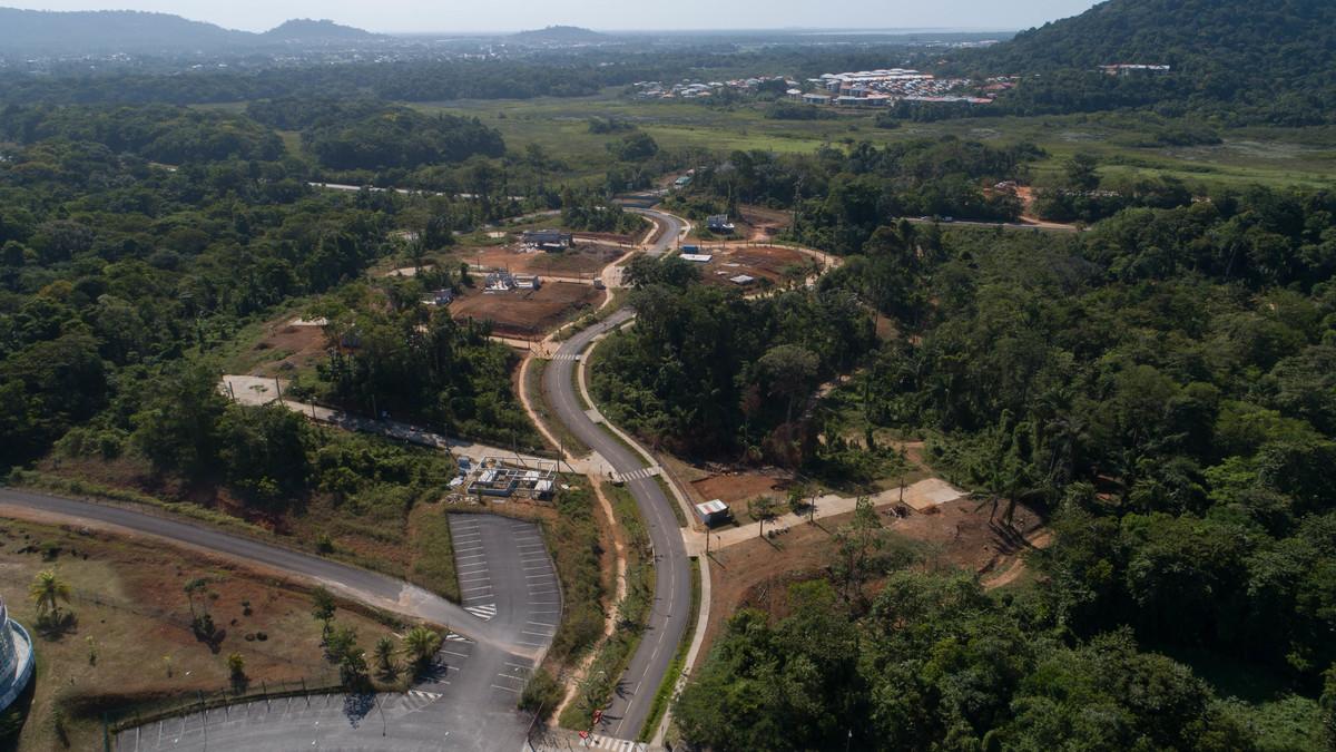
The development of the first phase was delivered in 2018, individual homes are currently under construction. Work on the development of a second phase, mainly for collective housing, has begun, followed by a third phase with 2022 as the goal of project completion.
At the crossroads of the major axes of the agglomeration, this operation invests the exceptional nature of its territory to develop while preserving it thanks to the innovative and ancestral know-how of Guyana which integrates the characteristics of a sustainable development. Between forest, polders and an old sugar plantation, the operation asserts itself in the identity of the Guyanese habitat: respect for the landscapes and the natural elements, optimization of the resources of the site for the development of the networks, durable constructions (materials local sustainability, bioclimatic architecture, energy performance, water management ...).
With 12,000 m² of shops and economic activities, two school groups, a college, public facilities and infrastructures, the Eco-district will provide adapted networks for a balanced and sustainable urbanization favoring a social and generational mix.
Programme
- Housing
- Offices
- Businesses and services
- Public facilities and infrastructure
- Public spaces
- Green spaces
Project progress
- Management phase
- Delivery phase
- Operational phase
Key points
- Quality of life
- Biodiversity
- Energy /Climate
Approaches used
- Ecodistrict national label
Certifications
- Ecodistrict national label
Data reliability
Self-declared
Type of territory
French soil of South America, Guyana has extraordinary geographical and human characteristics, creating special needs.
With an area of 84,000 km², or 16% of metropolitan France, Guyana is the largest department in France. The majority of inhabitants, however, focuses on the coastal fringe between Cayenne and Saint-Laurent du Maroni.
Its exceptional forest biodiversity covers 95% of the territory. Its first-rate fishing, forestry, mining and energy resources, and of course the Kourou Space Center, give it many advantages.
Unlike other French regions whose population is aging, half of the Guyanese population is under 25 years old. Population pressure is high (+ 2.6% per year according to INSEE), mainly due to an exceptional birth rate. In 2016 the population of Guyana is according to the INSEE of 268 000 inhabitants and its projection to 2040 is 540 000 inhabitants.
Climate zone
[Am] Tropical Monsoonal
Office floor area
11 000 m²
Commercial floor area
9 000 m²
Public facilities floor area
38 900 m²
Housing floor area
122 000 m²
Number of residential units
1 458
Number of social housing units
741
Project holder
Project management
- The DEAL
- The Regional Council
- The General Council
- The CACL
- The Caisse des dépôts
- The Conservatoire du Littoral
- The CCIG
- The project management team
Project stakeholders
Atelier Marniquet (Paris) and Yves le Tirant (Guyana)
Construction manager
Architect: Atelier Marniquet (Paris) and Yves le Tirant (Guyana), Two architectural firms are associated for the programming of the eco-district:. Yves Le Tirant, DPLG architect, local agency manager. Vincent Marniquet, urban architect, director of the Atelier Marniquet agency: Winners of the competition, the two agencies accompany the municipality to date in the definition and programming of the eco-district. Landscaper: Urban component, landscaper, hydraulic: Winner of the competition, the structure accompanies the municipality to date in the definition and programming of the eco-district. Technical or specialized studies in sustainable development: Acting Environment and Biotope MDTS and Alter: Economist and environmental engineering: Winner of the competition, the two structures accompany the municipality to date in the definition and programming of the eco-district * Others: DRAC, Michel COLARDELLE, director
SOLUTIONS
- communale (working meetings, information meetings, municipal council)
- intercommunal (CACL)
- Regional (regional representatives related to planning skills, sustainable development, equipment, economic development, social development ...)
- CACL
- DREAL
- Region
- Department
- DAAF
- DRAC
- DJSCS (youth, sport, social cohesion)
- Conservatoire du Littoral
- NFB
- DSDS
- local association for the promotion of urban and sustainable architectural quality (AQUAA, house of architecture of Guyana)
- association for the preservation of fauna and flora and awareness of ecology and eco-citizenship (Gepog, Kwata, French Guiana ...)
- sports associations cultural associations (museum of Guyanese cultures)
- Urban project governance
- Citizen participation
consultation
People consulted about the operation:
Elected: Concertation of the elected representatives on several scales:
Inhabitants: neighborhood ward committees, participatory and thematic workshops organized (according to themes, with associations) and projected, information meetings open to the public, information via the town hall website.
Experts: Expert consultants in impact studies, hydraulics, energy management, sanitation systems ...
Administrations:
Association:
Quality of life / density
Until recently, urban growth in French Guiana has been mainly characterised by projects that prioritise housing needs in the light of strong demographic growth, based on a logic of land opportunity (one by one) and without an overall vision that anticipates the challenges of sustainable development. In a Guyanese territory that is very physically constrained by water issues, this mode of "development" has produced a dissemination and spreading of residential areas in the form of housing estates that are often isolated and dissociated from each other (absence of urban sprawl other than service). This mode of development by land opportunity is combined with a rejection of the urban way of life (very low attractiveness of cities, often synonymous with nuisance and insecurity) and with a very strong culture of individual housing associated with a relationship with the land. In addition to these dominant processes today, spontaneous urbanization is one of the main characteristics and problems of French Guiana's development. Moreover, the very strong demographic growth requires an anticipation of needs in a territory that is, on the whole, limited in urbanization given the physical constraints. The expected prospects show the need to engage development modes by prioritizing urban renewal and controlled urban extensions, which can only be done with a strong public land policy, and through the first land transfer agreements between the communities and the EPAG. It is in this context that the need arose to undertake sustainable urban development projects, based on objectives of lower space consumption, urban compactness, urban renewal, in a forward-looking vision, in programming that goes beyond simply responding to housing needs by integrating, for example, the issue of economic development, which is a major challenge for French Guiana.
CONCEPT 1: SPACE SAVING / URBAN RENEWAL
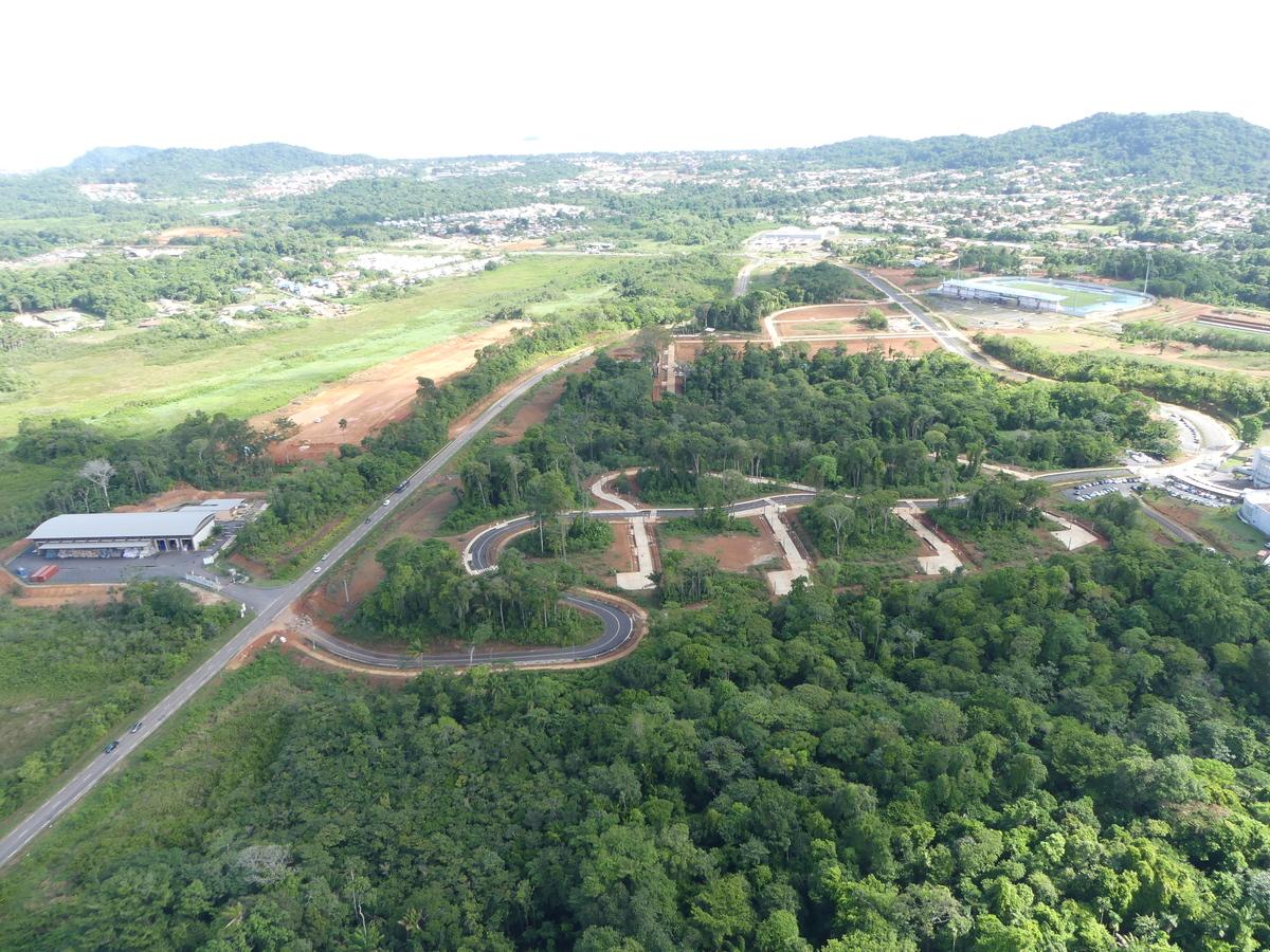
The development challenges are linked to the very significant growth of the Guyanese population over the past twenty years. All types of spaces, urban and agricultural, must be created in large numbers to meet the needs of the population. The land control policy, in anticipation of future development needs, is relatively recent. It is only in the last ten years or so that the various communities have gradually become aware of the need to develop their territory and the vast scope of the task. Apart from the implementation of urban pre-emption rights, which are rarely used in practice, the first major intervention is the creation of development areas in 2007 in the territories to be developed registered in the SCOT of the urban community of the coastal centre. Since its inception, the EPAG has set aside 8500 hectares of land reserves for its benefit or transferred back into the land transfer agreements that the institution has concluded with the communities for just over two years. The work carried out as part of the establishment of land portage agreements makes it possible to support local authorities in the operational implementation of their political projects.
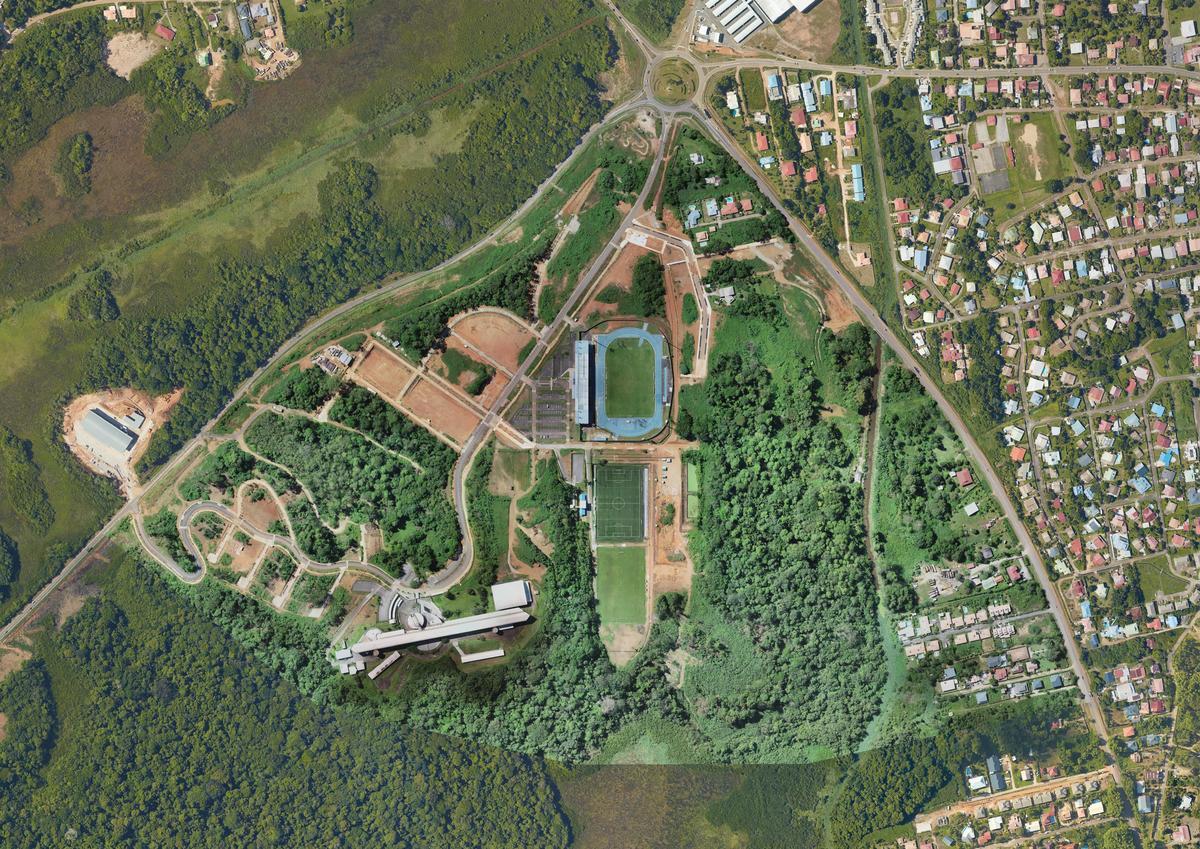
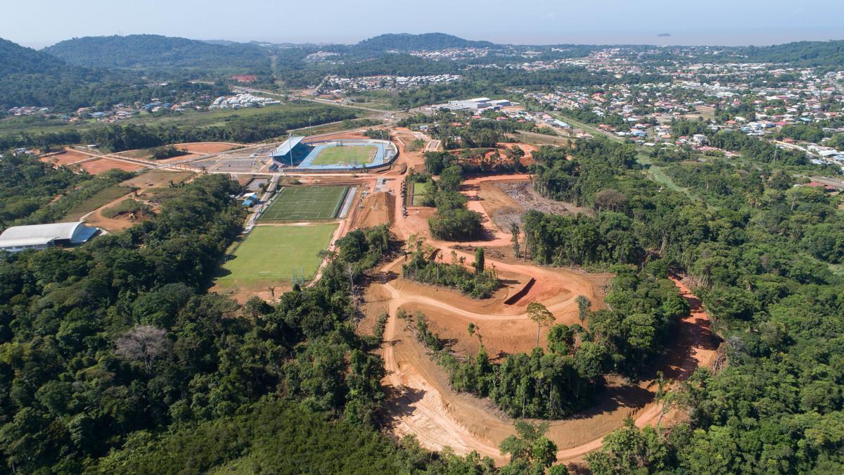
Land control contributes fully to the success of the project. In order to quickly implement a development phase of the urban project designed in the urban design phase, it was considered to limit the district to an area composed of 80% public land, half of which belongs to the State. The perimeter chosen for the district is located at the heart of the urban project, at the intersection of RD 23 and 24 linking the municipalities of Cayenne, Rémire-Montjoly and Matoury. This strategic location makes it the real point of articulation of the urban project. Its completion will create the dynamism necessary for the realization of the other Eco-district of the urban project. The operational phasing of the district made it possible to highlight the completion of a first phase of work on exclusively public land.
NOTION 2: SPACE OPTIMIZATION / DENSITY
The challenge of optimizing and enhancing the space was central to the general design of the project, at several design levels: At the territorial level, set a clear limit to urbanization, in relation to areas of great landscape and environmental value.
On the scale of the district itself:
- In the choice of the layout of public spaces, taking into account the topography (contour line) in order to optimize the land rights-of-way to be served and built.
- In the choice of stormwater management method in public spaces in order to reduce constraints on a plot scale and consequently to promote a higher density and a better organization from building to plot. The management of rainwater in the public space also makes it possible to guarantee the best functioning and sustainability of its management in a highly constrained Guyana climatic context.
On the scale of the built urban fabric:
- Through strong recommendations concerning the management of underground parking, also in order to optimize the constructability of land rights-of-way.
- Through typological choices of habitat by favouring the intermediary and the collective.
- Through a land division in good adequacy with these typological choices. The combination of these project orientations at several scales has led to the construction of a district whose density is notoriously higher than that practiced trend, while preserving a strong landscape identity in the built fabric.
Net density
Culture and heritage
One of the main principles of the urban project was to preserve and highlight all the elements already existing on the site, among other elements of heritage value, whether this heritage is natural or historic:
- The development of the Vidal dwelling, located outside the perimeter of district but whose access road leaves the neighborhood: This enhancement of the beginning of the road will be extended by a project of interpretation trail and the restoration of the ruins Vidal by the General Council.
- enhancement of the Canal Nord Sud and the natural areas that accompany it (the Canal Park)
- the development of the relief, in a project respecting to the maximum the existing topography the enhancement of the great landscapes with the installation of a clear limit of the urbanization
- enhancement of protected species (pineapple)
- the conservation of a maximum of wooded area due to a compact and dense urban project.
The Eco-district was not thought of as a piece of generic city according to the metropolitan model, but was committed, from its initial principles, to highlight all that can found the city of Guyana of tomorrow and in a specificity of identity specific to this culture, to this climate.
To respond concretely to these principles and beyond the first intentions, the project has integrated:
- The use of local materials, both in the public space and in architecture, especially wood and laterite, with an economic objective of strengthening the local production sectors even before the aesthetic question.
- Integration of rainwater management in public spaces, decisive management of the overall design of the project.
- Maintaining outstanding subjects and preserving heritage plant spaces identity element of local life
- The development of an architecture adapted to the local climate.
Social diversity
One of the major principles of the project in its programming aims at a diversity of the housing offer taking into account the very diverse population in both lifestyle and financial means. This diversity is made possible by specific work on the land division of the project, from the block to the plot. This diversity is indeed to be considered over the entire project perimeter and up to the block or even the plot: the project was based on a fabric making each land entity autonomous (and therefore evolving, and therefore sustainable). This classic cutting principle, unlike macro-lots, makes it possible to offer a high diversity of housing to the block, whether in architectural typology or to respond to social diversity; according to the rule of 3 thirds (social rental, assisted accession and free market). If the social mix is at the scale of the plot very difficult to implement, the typological diversity was as much as possible proposed (town houses, intermediate and small collective within the same plot).
Due to its strategic location, at the crossroads of the municipalities of Cayenne, Matoury and Rémire-Montjoly, the Eco-district is located near several employment and life basins justifying its attractiveness. The neighborhood's offer of businesses and activities will also allow residents to benefit from these services without systematically using their vehicles.
A comparative study of property and real estate prices has enabled EPAG to verify the value of its land charges. The diversified housing offer must enable all households to find a suitable habitat for their residential trajectory. A special effort was made in the marketing of free construction land (60 lots), sold directly by EPAG to individuals, in order to smooth their price to make them accessible to the greatest number. Half of these lands will be sold to first-time buyers. This measure complements an offer of housing whose urban forms and their modes of financing must allow everyone to be able to extend their residential journey in a neighborhood close to all amenities.
Social inclusion and safety
The design of the project had to reconcile environmental principles such as the balance of cuttings and embankments and the city of short distances, while trying to provide answers to the accessibility of people with reduced mobility. For this reason, when the travel chains do not allow for travel in compliance with accessibility standards, the offer of parking PRM or the public transport service will ensure access to local activities and services.
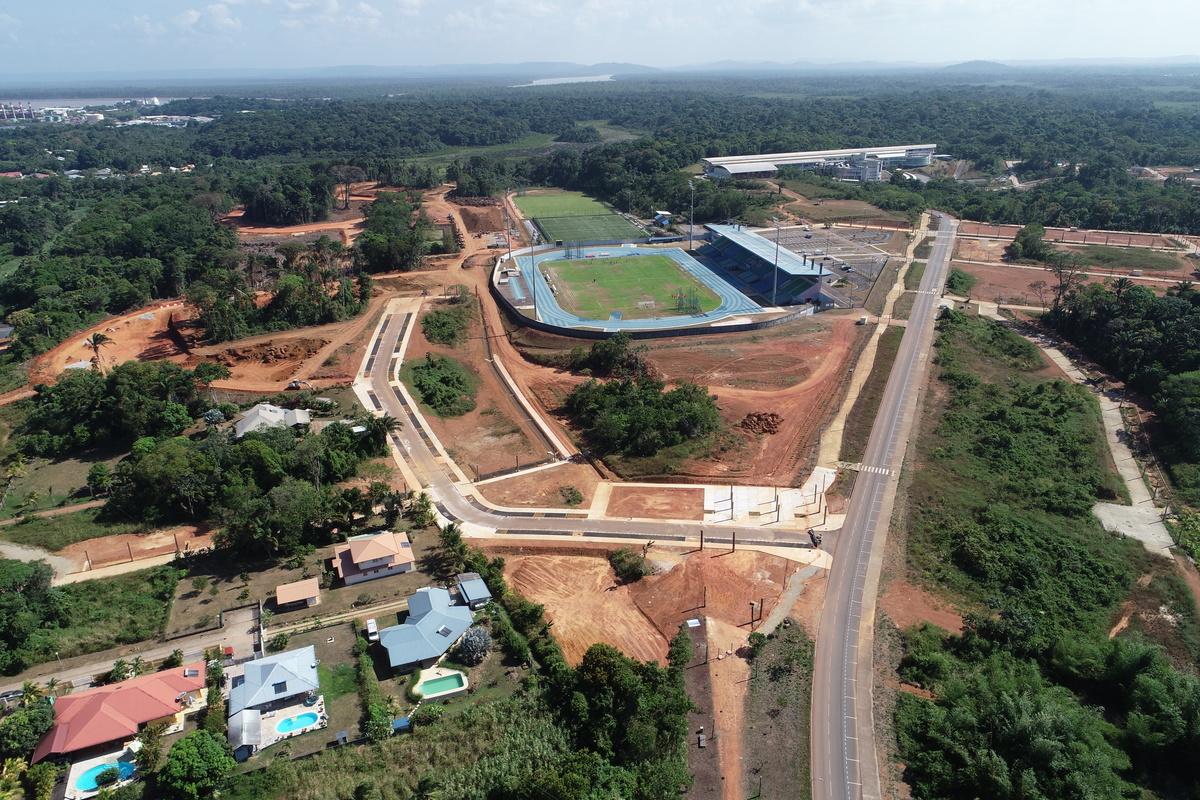
The integration into the public space project of meeting places and exchanges such as gardens and plots, aims to promote the collective dynamics. In addition, the presence of football fields within the eco-district may favor neighborhood-specific sports associations.
The public spaces of the eco-district de Rémire-Montjoly have been designed to be easily appropriated by its future inhabitants. Their structure according to the principle a function equals a material equalizes a color facilitates their readability by the user and the manager. Places, places of animation of the district, will be held by a built frame whose facades will be turned towards the public space. The soft movements will be illuminated and sheltered distinctly from the roadways.
Ambient air quality and health
The eco-district operation was the subject of an impact study and an authorization dossier under the Water Act, which made it possible to establish the sanitary state of the site, the nuisances identified and the impact reductions envisaged. An iterative work between the consulting firm, having carried out the impact study and the water law file, and the project management team made it possible to integrate very early on the measures planned to reduce or compensate for the nuisances. Thus, deforestation and earthworks will be limited to what is strictly necessary and valorised in the re-use of lateritic materials and the reuse of green waste. Remarkable trees and two large wooded areas will be kept in the reference mass plan. The waterproofing of the soil will be compensated by a hydraulic system of valleys and buffer tanks to clean the area.
The traffic will be fluidized by the connection of the street of the high school with the departmental road 24. The high school students will be able to join the establishment with feet by borrowing a mall shaded, secure and enlightened.
Local development
First of all, it is worth recalling the particularly strategic geographical location occupied by the Eco-distrcit. Thus, the future district is located at the intersection between the road connecting the airport to the agglomeration of Remire-Montjoly; the only road leading to the only industrial port in the Guyana region and the area is the first activity zone in French Guiana. Thus, the supply of housing placed next to such a pool of jobs seems particularly relevant.
Then, the EcoQuartier intends to support the local economic dynamism through 3 axes of action:
- The Eco-district, a structuring project for the construction economy in French Guiana. The construction sector is the third largest employer in French Guiana (after the civil service and trade) with more than 13% of establishments in Guyana. Thus, while it is estimated that the public works tenders in 2009 amounted to 430 million euros, the EcoQuartier project would result in an order of 40M € of public works spread over 10 years and not less € 180 million in housing construction. There is no doubt that such a volume of order has a significant impact on the private sector in Guyana.
- The Eco-district, promoter of local sectors. Since an district is a development project aimed at integrating sustainable development objectives and reducing its ecological footprint, it is a question of limiting energy and raw materials consumptions, of using local resources, of healthy, natural materials or recycled. Following the results of the analysis of the main contractor and the support of various consular bodies (including the CCIG) the future district will highlight the local sectors: wood, lateritic materials. While the construction market is dynamic, local resources are not highlighted, the project of Ecoquartier aims to promote the increased use of local materials, both in the public space and in architecture, in particularly wood and laterite. This initiative will not only have an economic impact of sector support but will also promote local productions and thereby improve the visibility of these sectors of activity (territorial marketing).
- The Eco-district, a project supporting the corporate real estate market. While the Guyanese market is marked by a shortage of quality business real estate, the EcoQuartier offers no less than 20,000 m² of shops, activities, services including a business area at the entrance of the neighborhood, and this in a strategic area for the development of the private sector.
Functional diversity
The Eco-district was based on a principle of urban programming (in contrast with a residential development that meets only housing needs) integrating the widest possible range of programs of public and private facilities, services and businesses necessary for life. a neighborhood of habitat and activities:
Beyond the 3 school groups meeting the needs of the neighborhood and neighborhoods, the project integrates:
- Commercial DRCs (convenience stores) or for economic activities and services
- 2 'urban stacks', buildings strategically located (place of intensity) and can regroup social and cultural facilities (association hall, concert hall / rehearsal, ...)
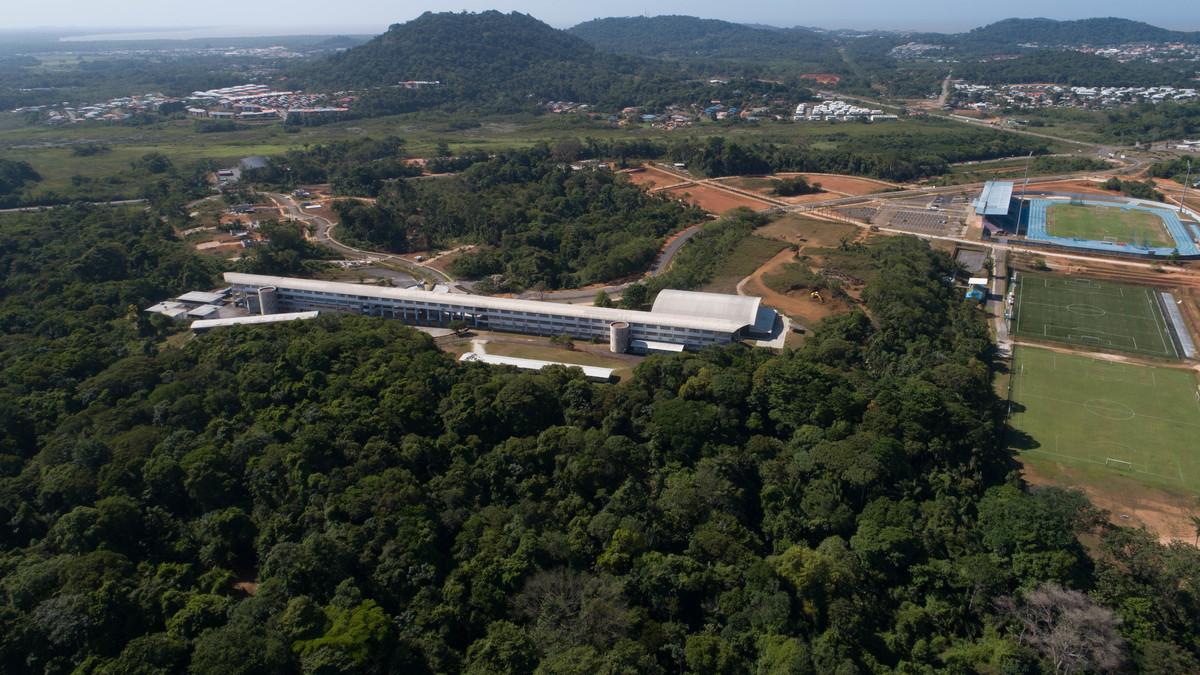
- Existing sports equipment and valued in the project (advanced base, local and national scope)
- An existing high school valued in the project
- Tourism-related activities (hotels) related to the history of the place, and activities related to the port of Degrad des Cannes (regional scale)
The 'run-of-the-river' urban development observed in Guyana has, until too often, been a response to housing needs in relation to population growth. The urban programming approach of the EcoQuartier introduces missing urban functions to neighboring neighborhoods, and will constitute a new centrality of the city through these facilities.
% of office area
% of commercial area
Circular economy
- The Eco-district, a social district In order to support the Social and Solidarity Economy (SSE), EPAG has decided to impose integration measures in the Business Consultation File for work related to the district. In addition, the neighborhood provides for the implementation of social projects, such as the implementation of a bar association in phase 3 ...
- The Eco-district, a sustainable neighborhood The efforts of the EcoQuartier to support local sectors with a "sustainable" character have been and will continue to be important. Thus, as specified in concept 1, the EcoQuartier project wishes to support local sectors, particularly the production of local materials in the construction process. In addition to imposing the use of wood in dwellings, EPAG wishes to use the site's materials to reactivate the lateritic brick production sector. In addition, the structuring and exemplary character of the EcoQuartier has led to the active support of the development of the biomass sector (an industry being structured) on urban clearing projects. Thus, the realization of the district should be accompanied by a valorisation of the green waste thanks to the biomass sector (knowing that energy represents a major stake for Guyana which knows a strong demographic growth and a selling price of the electricity twice as high as the cost price.
Finally, it is not impossible that, in the long term, the district project will be accompanied by a reactivation of polders for local agriculture.
Mobility strategy
All primary roads in the Eco-District will be meshed with the public transit network. Seven bus stops will be located in the district and within 150 m of the apartments. These bus stops will be accessible to people with reduced mobility. A project led by the CACL will connect the Eco-district to the city centre by means of Public Transport on a Clean Site. This should be completed before the completion of the BIA. It will promote multi-modality. Although at the beginning of the project, there was no urban transport line or service project on Rémire-Montjoly, the challenge of making the city compact and accessible pushed the designers to integrate enough bus stops to serve the entire area of the district. As there were no interlocutors to deal with the issue, it was decided not to provide for rights-of-way dedicated to a TCSP for financial reasons. However, since the acquisition of transport competence as a result of the transition to an urban community, the CACL has developed a project for two bus lines with a high level of service consistent with current and future land use planning projects. Thus, although the eco-neighbourhood does not have a dedicated public transport infrastructure, it is located in direct proximity to one of the multimodal exchange hubs that will be created in phase 3 of the BRT project in direct connection with the roundabout entrance to the neighbourhood.
Soft modes are favoured, with the creation of a large right-of-way for cycles and pedestrians to move along the main artery of the district, separated from the roadway by a high-quality landscaped area. Secondary roads, which do not support transit traffic, are built as shared roads whose layout promotes the coexistence of soft modes with vehicle traffic, reducing gauges and promoting the driver's sense of insecurity. The purpose of public space is to reverse the balance of power between the soft mode user and the motorist, thereby creating safety conditions through increased attention and reduced speed.
The neighbourhood layout encourages active modes of travel (pedestrians, bicycles, skates, etc.) within the neighbourhood and to adjacent neighbourhoods. Indeed, the emphasis has been placed on the development of soft practices and comfort of use at the district level in a general context where the car remains dominant and'occupies most of the space' with few spaces dedicated to soft modes.
- A large place for soft links in the projected public space mesh
- Particular care for the comfort of use of public spaces: "walking in the shade with feet dry".
The implementation of this network dedicated to soft mobility could be extended/continued in the neighbouring districts subject to safe crossing at RD 23 (installation of fire crossroads) and urban treatment of these axes at least at these crossroads. A soft link accompanying the North-South canal, the founding and structuring axis of the overall project (competition), could later be implemented. This development would strengthen the neighbourhood's relationship with the city.
In addition, the public transport offer, mobility services and information systems promote alternative use of the private car by different means (routes, frequency, time slots, connections, inter-modality, waiting times, etc.)
- Opening up the rue du Lycée on the Matourienne + rue des Coteaux for a TC route through the district
- 7 stations planned positioned at the level of school facilities and central areas in the districts
- No dwellings more than 150 m from a CT
- TCSP stop in the vicinity
- Information on the locations of services within the eco-neighbourhood as part of the welcome booklet.
Le projet d'écoquartier permet de créer un parcours de voie primaire liant le quartier à une voie primaire de déplacement vers une commune limitrophe et les autres quartiers de la ville de Rémire-montjoly, promouvant de ce fait le désenclavement du secteur et leur offrant la capacité d'être desservis par les bus. Le parcours de transports en commun emprunterait ainsi la rue du Lycée et la ru des côteaux pour pouvoir lier les quartier du bourg de Rémire. Au sein du quartier 7 stations de bus sont prévues, positionnées au niveau des équipements scolaires et des espaces de centralité des quartiers. Ainsi les attracteurs principaux de déplacement sont irrigués directement par le transport collectif. Ainsi l'ensemble des logements est placé à une distance inférieure à 150 mètres d'un arrêt de bus. Le positionnement de ces stations permet aussi de rendre accessible le quartier par les PMR. En effet le respect du relief par l'aménagement a pour conséquence de ne pas disposer des pentes réglementaires pour l'accessibilité des PMR. L'écoquartier a été conçu de sorte à aménager des zones distinctes et significatives en respect des réglementations accessibilité en vigueur et de les rendre accessibles entre elles par le réseau de transports en commun. Tous les logements disposent d'une station de bus accessible aux PMR. Un des pôles d'échanges des lignes de bus à haut niveau de service devrait se situer à proximité du quartier, en lien direct avec le rond-point Adélaïde Tablon, une des portes d'entrée du quartier.
Smart City strategy
EPAG has approached the operator of a public service delegation for the deployment of the fiber optic backbone linking Suriname to Brazil. Part of this ridge is already laid on the island of Cayenne, the EPAG will connect on this primary network to serve the entire Eco-district fiber. The Eco-district will be able to receive both the copper and fiber optic network in FttH for housing and offices, shops, two boxes of connections are provided for all transferable lots. Specific reservations will also be provided for the CCTV network.
In addition, cultural equipment is programmed in phase 1 of the EcoQuartier. This one aims in particular to favor the free access to the Internet at the very top or very high speed.
Water management
The problem of AEP in Guyana is a major issue. Awareness of the importance of the protection of this resource is borne by the Community of Agglomeration Center Coast (CACL).
Moreover, the climatic and geological conditions of Guyana are specific and do not allow infiltration. Rainwater transport is planned by means of wadding which allows a reduction of the pollution hydrocarbons and suspended matter, as well as a slowing down of the flow. A collective network of wastewater collection has been planned because of the desired density of the neighborhood.
The noues, path of the water, are devices qualifying public spaces of the district. No plot retention has been planned given the specific climatic conditions in Guyana. Water retention is planned in public spaces valued as green spaces open to all. Their emptying times were calculated to limit mosquito nesting.
Soil management
In the 2009 competition, the bias was to preserve the 80% of the natural environment of high environmental quality (in particular excavated creek). This bias has established a limit to urban development, and has preserved a natural environment that contributes to the stormwater management of the area. In addition, the project involves the treatment of pollution and the reduction of runoff velocities through valleys and the development of the floodable forest in the retention basin.
Waste management
The good sorting and collection practices presented in the charter of the Center Coastal Agglomeration Community (CACL) have been taken into account for the development of collection infrastructures in public spaces.
The altimetric layout of the project was guided by the objective of balancing cuttings and embankments at the project scale. In addition, the project plans to use materials extracted from the site in concrete pavements of sidewalks. Finally, all deforestation waste will be used for energy production and timber production.
All non-recoverable deforestation waste in timber will be used for energy production (biomass power station).
The good sorting and collection practices presented in the CACL charter have been taken into account for the development of collection infrastructures in public spaces.
Biodiversity and natural areas
A flora fauna inventory was carried out as part of the district's application for authorization under the Water Act. The protected species likely to be impacted by the project were saved by transplanting into natural areas. At the pre-creation stage of the district in 2009, the project's focus was on preserving the remarkable biotope of the excavated creek. Finally, the management of rainwater through the valleys allows the development of a biotope specific to the district.
The rain-fed management of stormwater is the blue and green frame of the project. In addition, the maintenance of the green spaces of the excavated creek and associated park constitute areas of high environmental quality integrated with the urban development of the district. .
The development of the blue and green grid in public spaces associated with open-space residential areas will allow the maintenance and development of biodiversity in the project.
De-foresting and edge reinforcement as the project develops enable the maintenance and renewal of a natural area favorable to the development of a balanced biotope. On the other hand, the project owner has planned to have a follow-up of the ecological issues of the site in the works phase by a specialized design office.
The designer has planned green cover species in the green spaces that do not require regular mowing. In addition, the choice of species for landscaping treatment focused on species that do not require regular chemical treatments or watering after rooting.
Climate adaptation, resources conservation, GHG emissions
Prescriptions and architectural choices for the climatic comfort of the dwellings have been included in the batch recommendation books.
It is conceivable, in addition to the common law actions launched in the territory aimed at protecting the environment and controlling energy, in addition to the explanatory requirements provided for in the welcome booklet, to carry out actions to raise awareness of first inhabitants and the population of the island of Cayenne about lifestyles in bioclimatic housing and modes of management and functioning of the eco-district (role of the valleys for example)
Reasons for participating in the competition(s)
One of the strong points of the Georges Othily Eco-district is the place given to architectural creativity to meet the ecological challenges but also the topography of the site. The relationship to topography and the division into land in situations that are each time specific to the urban and landscape plan has led to the definition of constructible land entities that are unique in their situation and their constructability potential. This very strong contextualisation of each site, combined with the general rules of the Eco-district and the rules specific to the right-of-way (address, etc.), leads to a minimum urban or even architectural singularity of each operation. The principle of a division into distinct project units at the land level but also in the choice of a specific architect for each project unit responds to the desire for a strong diversity of architecture both in their typology and in their architectural expression. This desire for diversity and the uniqueness of each operation is in line with the promotion of architectural creation. In addition, integration into Social Evolutionary Housing construction programmes, even if this share is symbolic (1%, i.e. 15 housing units to be built in phase 2), makes it possible to address the issue of social accession for the most disadvantaged classes. This economic and social approach to housing will necessarily lead to a particular constructive and architectural strategy.Building candidate in the category

Grand Prix Ville Durable

Prix du public
Other case studies
Contest